I-14 Central Texas Corridor Study
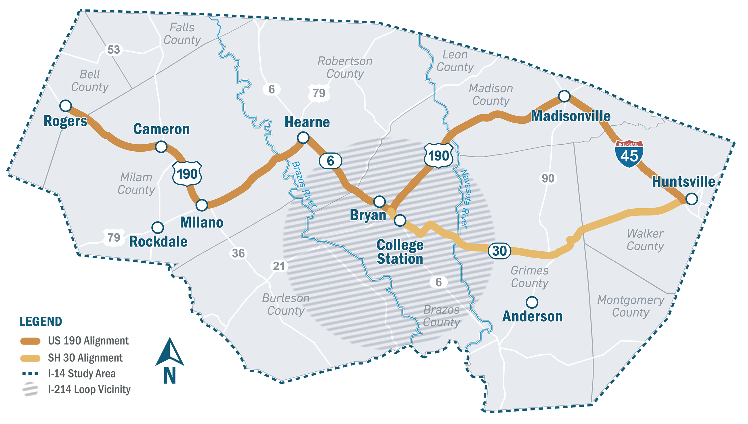
The TxDOT Bryan District is studying the future I-14 Central Texas Corridor, which generally follows US 190 eastward from Rogers in Bell County to Huntsville in Walker County. This Study will determine the feasibility of a corridor and route for a roadway facility that meets interstate standards.
The I-14 Central Texas Corridor Study (Study) will align with on-going I-14 development and planning efforts in Texas to ensure consistency and continuity of the interstate corridor from west Texas to Louisiana. The primary goals of the I-14 project are to provide safe and reliable east-west connectivity, improve traffic mobility including freight, relieve congestion caused by increasing traffic demand, and support deployment from our military bases to strategic ports.
In November 2021, the Infrastructure Investment and Jobs Act (IIJA) designated the I-14 System in Texas for further development, along with Loop I-214 around the Cities of Bryan and College Station. Because this loop is located entirely within the Study area and expected to overlap with I-14 as it passes through the Bryan-College Station area, evaluation of Loop I-214 will be included as part of the I-14 Study.
I-14 development process
Development for a project of this size starts with a feasibility and route study which is anticipated to take 7 years. The Study aims to implement a transparent project development process, collect public and stakeholder input, and identify potential risks. The Study area will include 11 counties between Rogers in Bell County to Huntsville in Walker County, approximately 125 miles in length. The Study began in 2022 and will be conducted in three phases, each including public involvement:
- Phase 1 – Corridor Feasibility Study (3 years anticipated)
- Outcome: Recommend up to three feasible corridors to move forward into the Route Study.
- Phase 2 – Transition Period (1 year anticipated)
- Outcome: Develop a Route Study Implementation Plan and collect additional data as needed in preparation for the next phase.
- Phase 3 – Route Study (3 years anticipated)
- Outcome: Evaluate up to three viable route alternatives and identify a recommended preferred route; prepare preliminary cost estimates and a Schematic Implementation Plan for future project development.
Future phases
Constructing a completely new interstate highway or upgrading existing roadways to interstate highway standards can take multiple years or even decades. Specific project development from feasibility to construction can take as many as 20+ years.
Funding and a timeline have not been established for future phases of I-14 and Loop I-214 corridor development. Next steps will include schematic and environmental phases to refine the roadway location and develop a design, anticipated to take place in segments as identified in the Schematic Implementation Plan. Future phases of project development will include continued public involvement, identification of right-of-way, and National Environmental Protection Act (NEPA) clearance. Detailed design and construction plans would then be developed, followed by right-of-way acquisition prior to construction.
Get involved
Public involvement is a key component of this Study. Opportunities for public participation include meeting with working groups, regular coordination with elected officials and government staff, stakeholder meetings, community surveys, and public meetings.
Additionally, in a separate planning effort, TxDOT’s Corridor Planning Branch is leading a statewide planning effort to develop an implementation strategy for upgrading TxDOT’s I-14 System of highways to interstate standards. This strategy is being developed in coordination with other TxDOT Districts where the roadways that comprise the I-14 System are located. Additional information about this statewide planning effort can be found here.
- 1st Round Open House Public Meetings – Fall 2023
- 2nd Round Open House Public Meetings – Summer 2024
- 2nd Round Open House Public Meetings – Summer 2024 (Rescheduled meetings)
- 3rd Round Open House Public Meeting - Summer 2026
Bryan/College Station MPO Thoroughfare Concept
The Bryan College Station Metropolitan Planning Organization (BCSMPO) proposed the location of an outer loop in the 2050 Thoroughfare Concept. The I-14/I-214 Study will use the outer loop as a starting point when developing potential alignment corridor alternatives. The final I-214 alignment corridor will be determined by following the National Environmental Policy Act (NEPA) process, which includes public involvement and environmental assessments throughout the I-14/I-214 Study.
Downloads
*Please reference the following project name and number:
I-14 Central Texas, 0917-00-050