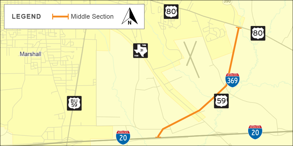
US 59/I-369 Middle Section (SL 390) from US 80 to I-20
Loop 390 / US 59 / I-369 Corridor - Harrison County
CSJ: 1575-05-024, 0495-09-065 (Phase 1)
CSJ: 1575-05-025 (Phase 2)
Project description
The US 59/I-369 Middle Section extends for approximately 4 miles from US 80 east of Marshall to I-20 south of Marshall and is currently being developed. This roadway is being designed to interstate standards with plans to designate it as I-369 in the future. Schematic development and environmental clearance for the Middle Section are based on the potential for future frontage roads and direct connect access at the interchange of US 59/I-369 and I-20. The Middle Section will be constructed on new location requiring right-of-way acquisition from current property owners. The route will include interchange locations at US 80, FM 31 and I-20. The construction of this roadway section along with the sections to the north and south would relieve traffic congestion through Marshall on US 59 due to a growing population, provide safer travel through the state, improve emergency evacuation routes, and support economic development.

Typical sections
The proposed US 59/I-369 roadway will be constructed to include two 12 foot-wide mainlanes in each direction with 6 foot-wide inside shoulders and 10 foot-wide outside shoulders. Additionally, future one-way frontage roads could be constructed consisting of two 12 foot-wide lanes, 4 foot-wide inside shoulders, and 10 foot-wide outside shoulders. Additionally, bicycle and pedestrian facilities (not shown) will be developed to meet current design guidelines. Opposing mainlane traffic will be separated by a depressed grassy median and open ditch. The mainlanes and the frontage roads would also be separated by a grassy area with an open ditch. Ramps (not shown) will also be included at locations determined during project development justified in an Interstate Access Justification Report.

Phased construction
Initial phased construction of proposed SL 390 will include bridge and frontage road construction. The frontage roads located within the Eight Mile Creek floodplain are not included in this phase of the project. This link includes a schematic of the project with the green lines illustrating frontage roads and the purple lines illustrating bridges.
The proposed construction of future phases will include mainlanes and direct connectors. This link includes a schematic of the project with grey lines illustrating these.
Funding and letting information
The initial phase of this project is funded and is projected to cost $220 million. The estimated letting date for this section is 2026. Right-of-way acquisition could begin as early as fall of 2023.
The second phase would complete the mainlanes and grade separations to get to interstate standards. This phase of the project is currently not funded and projected to cost $335.4 million. The estimated letting date for this phase is 2026 pending funding.
Public involvement
The purpose of public involvement is to share project information and updates, present proposed schematics of the project and collect input from the community. TxDOT is committed to working closely with the community on this project. In January 2019 and August 2021, public meetings were held in Marshall, Texas to allow the public to view the proposed new location roadway and comment on the project. Visit the public meeting page to learn more and review all documents shown at the meeting.