SH 99 Grand Parkway segment G - I-45 North to US 59 North
SH 99 Grand Parkway overview
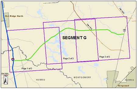
Segment G is an existing 13.7-mile, four-lane, controlled access toll road with intermittent frontage roads from I-45 North (the North Freeway) near Spring/the Woodlands to US 59 North (the Eastex Freeway) in New Caney through northern Harris and southern Montgomery counties.
Segment G is operated and maintained by TxDOT. Visit the TxTag website for more information.
The map below shows Segment G of the Grand Parkway. Each square indicates the limits of the detailed map of that portion of the segment. Select a link from the list below to view a detailed map of the segment. The detailed map will open in a separate window. The maps are large files and may be slow to download. Once in the detailed maps, use the zoom button in the toolbar to view the maps at 100 percent of their original size.
The latest approved environmental document for Segment G is the Final Environmental Impact Statement (FEIS) Re-evaluation, which was approved May 22, 2012.
Below are some of the other latest-approved Segment G environmental documents:
- Record of Decision (ROD) (issued Dec. 29, 2010)
- Final Environmental Impact Statement (issued January 2009):
If you have questions about Segment G or would like to request any other environmental documents, please email the Houston District.