SH 99 Grand Parkway segment E - I-10 West to US 290
SH 99 Grand Parkway overview
Control Section Job (CSJ) Numbers: 3510-05-047, 3510-05-048
The TxDOT Houston district is proposing design changes on State Highway (SH) 99, also known as the Grand Parkway, from Interstate (I) 10 West to US 290, in Harris County, Texas. The purpose of the proposed project is to manage congestion due to increased traffic based on an agreement between the State and the seven counties through which SH 99 passes. The proposed project is needed because the roadway is unable to maintain a stable traffic flow and vehicle speed. This toll road is operated under specific terms and conditions. One of those conditions is that the roadway must maintain a stable flow of traffic and vehicle speed.
Current conditions/project background
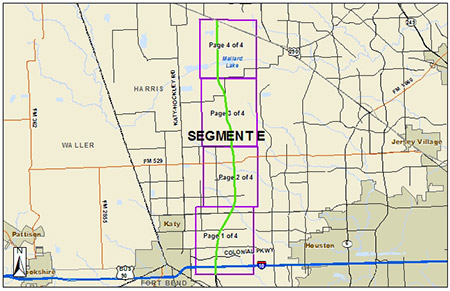
Segment E is an existing 15.2-mile, four-lane, controlled access toll road with intermittent frontage roads from I-10 West (the Katy Freeway) near Katy to US 290 (Northwest Freeway) near Cypress through western Harris County.
Segment E is operated and maintained by TxDOT. Visit the TxTag website for more information.
The map below shows Segment E of the Grand Parkway. Each square indicates the limits of the detailed map of that portion of the segment. Select a link from the list below to view a detailed map of the segment. The detailed map will open in a separate window. The maps are large files and may be slow to download. Once in the detailed maps, use the zoom button in the toolbar to view the maps at 100 percent of their original size.
The latest approved environmental document for Segment E is the Revised Record of Decision (ROD), which was issued June 9, 2009. Segment E opened to traffic in 2013.
Below are some of the other latest-approved Segment E environmental documents:
- Final Environmental Impact Statement (FEIS) Re-evaluation
- Summary - Official Record of Response to Comments on FEIS
If you have questions about Segment E or would like to request any other environmental documents, please email the Houston District.
Proposed improvements
- Construct one additional main lane in each direction
- Construct 10 to 11-foot-wide inside shoulders
- Replace cable barrier with concrete traffic barrier
Additional information
The entire project would be constructed within existing TxDOT right of way (ROW) and would not result in any residential or non-residential displacements. The proposed project would be funded with toll revenue for a total of approximately $157 million.
Widening the roadway is required by an inter‐local agreement that requires improvements when the roadway is unable to maintain a stable flow of traffic and vehicle speed.
Next steps
- Environmental decision and detailed design - estimated between mid-2025 to early 2026
- Construction - estimated to begin mid-2026