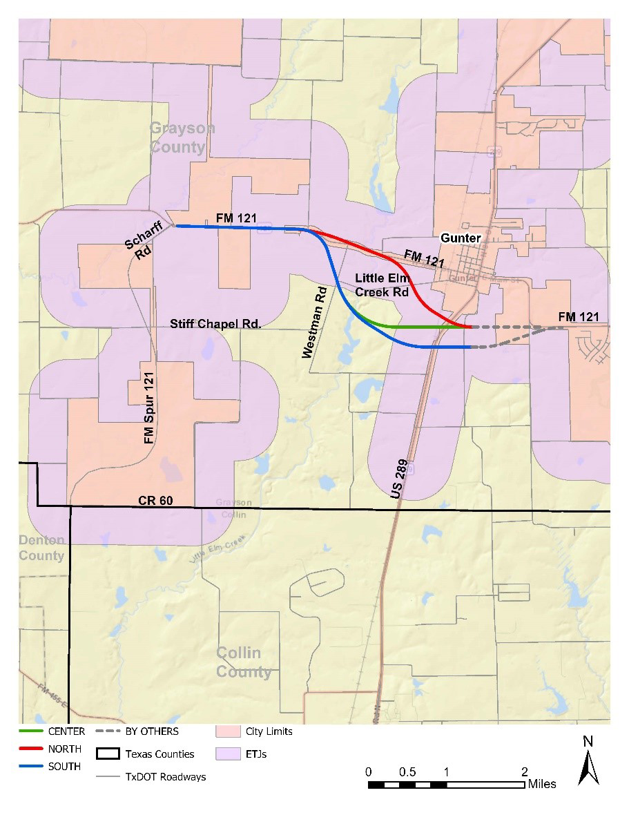
FM 121 - Gunter Relief Route
Overview
TxDOT Paris District, with support from the Grayson County Regional Mobility Authority, is proposing to construct a new location roadway from Scharff Rd, approximately 4.0 miles West of Gunter to SH 289, south of Gunter in Grayson County, Texas, referred to as the Gunter Relief Route. The approximate length is 3.6 miles. The map below shows the project limits.
Project background
According to the history of Gunter's website, Gunter has started to experience overflow growth from the northern Metroplex suburbs, due to its location on SH 289 and future tollway route. The Dallas North Tollway’s (DNT) initial planning is underway for a proposed 13.7-mile extension from US 380 to FM 428 (Phase 4A) and from FM 428 to the Grayson County line (Phase 4B). The extension would consist of a limited access toll road with six main lanes and six frontage roads. Additional phases are looking to extend the DNT from the Grayson County line to FM 121 in Grayson County. The Grayson County Thoroughfare Plan map from 2018 shows the DNT potentially expanding even further north than FM 121 all the way up to US Highway 75.
FM 121 and SH 289 are both principal arterials. With the future expansion of the DNT, additional traffic would be moving north to Grayson County. According to the Grayson County Thoroughfare Plan map from 2018, the future DNT will be connecting to FM 121 which would increase the traffic capacity on FM 121 and the surrounding area. Currently, FM 121 turns into W. Main Street, when heading east on FM 121, and goes into the town of Gunter. In order to access SH 289 from FM 121, drivers currently need to go through the town of Gunter.
The proposed Gunter Relief Route would help reduce future congestion, increase capacity and driver delay would decrease in the town of Gunter and the surrounding area. Safety for pedestrians and drivers should also improve with the proposed project.
Project timeline
The project is currently in the schematic and environmental phase, which is one of the early stages in the project development life cycle. The purpose of this stage of design is identifying, developing, and evaluating alternatives for engineering feasibility, selecting a recommended alternative, and developing environmental documentation to analyze potential social, environmental, and economic effects in accordance with the National Environmental Policy Act. Once a recommended alternative is determined, the project team will finalize a preliminary roadway design and perform an environmental assessment of the proposed project. This process includes two public meetings and a public hearing that will allow the public to learn more about the project and provide input on the project.
Public involvement
- Virual public meeting: Tuesday, Oct. 27, 2020
- Virtual public meeting with in-person option: Tuesday, June 21, 2022