SH 105 Improvement Project
Project overview
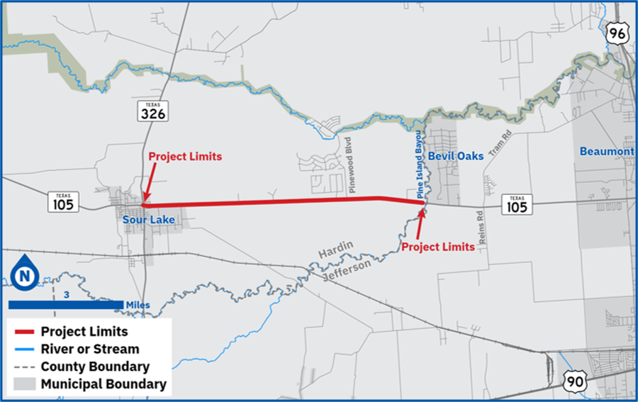
TxDOT Beaumont District is proposing to widen SH 105 in Hardin County, Texas from 0.1 mile east of SH 326 in Sour Lake to Pine Island Bayou near Bevil Oaks for 7.34 miles. The corridor connects to a five-lane cross section at each end of the corridor.
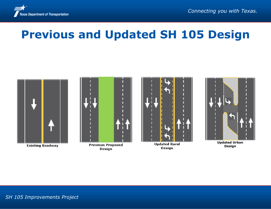
Currently, the roadway is primarily a two-lane undivided rural road with shoulders but no median. Center turn lanes are present between Countrywood Boulevard and Pinewood Boulevard. The corridor is part of the US National Highway System, the Texas Highway Freight Network and the Texas Trunk System.
Since the last official project communication occurred in November 2021 and the proposed design has changed, TxDOT afforded an opportunity for the public to review the updated design and provide feedback to the project team from Nov. 12-27, 2024.
Proposed improvements
For the urbanized section within the city limits of Sour Lake, from approximately SH 326 to Ryan Road:
- Adding raised medians to improve safety
- Adding median openings for turn lanes
- Adding elements such as a 10-foot-wide shared-use path and a 6-foot-wide sidewalk to accommodate both bicyclists and pedestrians
For the rural section of the project, from approximately Nevada Street to Pine Island Bayou:
- Adding a 16-foot-wide continuous two-way left-turn-lane
- Adding 10-foot-wide outside shoulders to accommodate both bicyclists and pedestrians
The purpose of the project is to improve safety and connectivity for travelers on SH 105. Approximately 144.7 acres of additional right of way and 5.3 acres of proposed construction, utility relocations and drainage easements would be required. Some residential and commercial displacements are anticipated. If your property may be impacted by this proposed project, please review the Right of Way page and the landowner's rights publications, which contains more information about the TxDOT Relocation Assistance Program concerning services and benefits for displaced persons and businesses if needed.
The need for right of way is to accommodate the drainage, clear zone and utilities along the roadway.
Summary of design changes due to public input
- Updated design matches existing number of lanes at eastern and western project limits.
- Updated design maintains access to adjacent properties.
- Updated design provides safe spaces for both turning vehicles and through traffic.
- Updated design simplifies drainage improvements.
- Updated design has been calibrated for today’s users of the corridor.
- Isolated raised medians and controlled left-turn lanes will still be constructed to improve safety.
- Design change includes a continuous left turn lane in the rural section.
The documentation of the project update is available from the comment period held from Nov. 12 - Nov. 27, 2024.
Get involved
- Nov. 18, 2021 - Virtual Public Meeting
- May 2, 2019 - Public Meeting
- Online project update - Nov. 12 - Nov. 27, 2024
- Nov. 13, 2025 - Virtual public hearing with in-person option
Please note that schedule times are estimates only and are subject to change.
Downloads
Final documentation
- Final environmental assessment (EA)
- Notice of availability - Final environmental assessment (EA)
- Finding of no significant impact (FONSI)
- Notice of availability - Finding of no significant impact (FONSI)
Proposed schematics for project update
- Schematic 1- SH 105 from SH 326 to Pignut Gully
- Schematic 2- SH 105 from Pignut Gully to Vaglica Drive
- Schematic 3- SH 105 from Vaglica Drive to Pinewood Boulevard
- Schematic 4- SH 105 from Pinewood Boulevard to County Line
Past summary reports