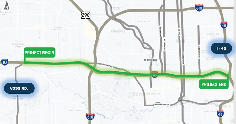
I-10 Inner Katy Managed Lanes Project (Voss Road to I-45)
Introduction
The TxDOT Houston District is proposing to reconstruct a 6.3-mile portion of I-10 between Voss Road and I-45, inHarris County. The purpose for the project is to reduce congestion, improve mobility, and enhance drainage on I-10 from Voss Road to I-45. Another desirable goal is to enhance connectivity of the current managed lane network.
Current conditions
Within the project limits, the current roadway is five lanes in each direction, with 12-foot-wide travel lanes. Shoulders vary from 8-feet to 10-feet-wide. Discontinuous frontage roads vary between two to three 12-foot-wide lanes in each direction. There are existing sidewalks along the frontage road.
Project background
- I-10 from I-610 to I-45 is the 7th most congested roadway segment in Texas (Texas Transportation Institute, 2023).
- I-10 is identified in the National Highway Freight Network as a primary highway for U.S. freight transportation.
- There is a gap in connectivity as the Katy Managed Lanes currently terminates near Voss Road.
- The Inner Katy Corridor crosses approximately 85 acres of the 100-year floodplain and becomes impassable during heavy rain events, such as Hurricane Harvey (2017) and Tropical Storm Imelda (2019).
- TxDOT held a virtual public meeting for Inner Katy improvements in February 2021. The public meeting presented preliminary concepts that also included the proposed METRORapid bus lanes, drainage improvements and new managed lanes. The public meeting summary is available online.
- TxDOT conducted a public meeting in February 2024 and presented two build alternatives (elevated and non-elevated managed lanes) plus the no-build alternative. Each of the build alternatives includes the addition of four managed lanes (two in each direction).
- Following the 2024 public meeting, TxDOT held additional coordination meetings with agency partners.
- Agency partners requested consideration of an additional build alternative that would enhance connectivity in the vicinity of Memorial Park.
Proposed improvements
The I-10 Inner Katy Corridor Managed Lanes Project would include the following improvements:
- Add Managed Lanes: Extend the Katy Freeway managed lanes from the current terminus at Voss Road to downtown Houston. These managed lanes would accommodate High Occupancy Vehicle (HOV) traffic from U.S. Highway 290 and I-10.
- Reconstruct the I-10 general-purpose lanes: Reconstruct the general-purpose lanes to improve the vertical clearance under the existing cross-street and railroad bridges.
- Drainage Improvements: Construct underground box culverts, add detention, and upgrade pump stations to address drainage issues and reduce the risk of flooding on I-10 during major rainfall events.
Partners
TxDOT and METRO are collaborating to improve mobility along the Inner Katy Corridor and coordinate planned projects between the two agencies: Visit their website for information on the METRORapid Inner Katy Corridor.
Additional information
TxDOT will conduct the next public meeting event in 2026 to introduce Alternative 3, as well as present traffic noise analysis findings for all proposed build alternatives, to gain community feedback and comments.
- Alternative 1: Elevated Managed Lanes – elevating managed lanes in between the existing general-purpose lanes would be designed with minimal property acquisitions (approximately 0.3 acres) or no residential or business displacements.
- Alternative 2: Non-Elevated Managed Lanes – the managed lanes would travel alongside the general-purpose lanes and would require right of way expansion, resulting in property acquisitions of approximately 12.5 acres and requiring the displacement of an estimated 52 residential properties and 30 businesses.
- Alternative 3: Hybrid Alternative - this alternative is still under development and potential impacts are still being determined. The hybrid alternative will include a section of non-elevated managed lanes and section of elevated managed lanes.
Inner Katy Corridor Managed Lanes project map
Next steps:
- Continue agency coordination
- Continue development of alternative 3
- Complete traffic noise analysis
- Conduct public meeting no. 3
- Summarize input received
- Evaluate alternatives/identify preferred alternative
- Complete draft environmental assessment
- Conduct public hearing
- Finalize environmental assessment
- Reach environmental decision
- Begin detailed design
Get involved
- Feb. 25, 2021 - Virtual Joint Public Meeting
- Tuesday, Feb. 6, 2024 - Virtual Public Meeting
- Thursday, Feb. 8, 2024 - In-person Open House
Downloads
Project reference:
CSJ: 0271-07-327