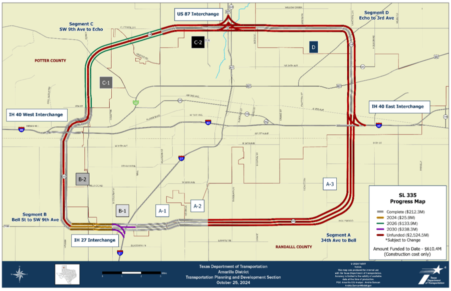
SL 335
Project overview
State Loop (SL) 335 around the city of Amarillo serves as a connection to national and regional corridors along with local arterials. The TxDOT Amarillo District and the Amarillo MPO have identified SL 335 as a top priority, transportation project candidate with the goal of upgrading the entire loop to a controlled-access roadway consisting of mainlanes, ramps, one-way frontage roads with bicycle and pedestrian accommodations, and four multi-level interchanges (I-40 east, I-40 west, I-27 south and US 87 north).
SL 335
SL 335 has been divided into four main segments corresponding to the quadrants:
The SL 335 Corridor Development study, adopted by the Amarillo MPO in October 2014, outlines that the majority of the loop can be upgraded to a freeway by generally following the existing alignment except a portion of Segment B referred to as B-2. Sub-Segment B-2 will generally be constructed on a new location alignment to re-route the loop around an existing portion of the loop which has evolved into an urban arterial (Soncy Road). Right-of-Way (ROW) acquisitions/relocations and utility relocations are expected on each segment.
Amarillo Helium plant
The SL 335 B-2 Sub-segment required right-of-way acquisition from the Amarillo Helium Plant property located at Helium Road and Amarillo Boulevard. The Helium Plant was previously determined eligible for listing in the National Register of Historic Places for its association with the federal government’s helium program as the headquarters and primary research laboratory. A Section 4(f) Net Benefit determination was executed based on a Memorandum of Agreement between TxDOT, Texas Historical Commission, and Advisory Council on Historic Preservation prior to TxDOT’s acquisition of a portion of the property.
Public involvement
Public input is crucial to this study's success, and all members of the community are highly encouraged to give feedback and suggestions on what improvement they do, and do not want to see. Public involvement opportunities will be posted here as they are scheduled.
Segment A, from Bell Street to Southeast 3rd avenue
Approximately 15.5 miles of proposed improvements that include a multi-level Interchange at I-40 east, mainlanes, ramps, frontage roads, grade separations at arterials and railroad crossings. The existing alignment from Bell Street to Washington Street (Segments A-1 and A-2) is four divided mainlanes, two-lane frontage roads, ramps, and grade separations at Bell, Western and Georgia Streets, as well as BNSF Railroad. From Washington Street to Potter County Line is a two-lane rural highway switching to four-lane divided to I-40 east. From I-40 east to SE 3rd Avenue is an existing four-lane undivided roadway.
East SL 335/I-40 interchange
- Limits: from SE 34th Avenue to SE 3rd Avenue
- Includes I-40 east five-level interchange
- Length: 2.1 miles
- Status: schematic & environmental approval in 2018
- Phase I: mainlanes, frontage roads, and I-40 2nd-level bridge
- Construction completed in 2022
- Phase II: SL 335 3rd-level bridge and direct connectors
- Unfunded
Sub-segments A-1 & A-2
- Limits:
- A-1: from I-27 to Georgia Street
- A-2: from Georgia Street to FM 1541 (Washington Street)
- Length: 3.8 miles
- Status: schematic & environmental approval in 2013
- A-1: mainlanes, frontage roads, and grade separations at arterials
- Construction completed in 2019
- A-2: mainlanes, frontage roads and BNSF railroad bridge
- Construction completed in 2018
Sub-segment A-3
- Limits: from FM 1541 (Washington Street) to SE 34th Avenue
- Length: 9.6 miles
- Status: schematic & environmental not started
- Construct mainlanes, frontage roads and grade separations at arterials through phased construction.
- No phases of construction funded
Segment B, from Bell Street to Southwest 9th avenue
Approximately 9.9 miles of proposed improvements that include a multi-level interchanges at I-27 south and I-40 west. New location sub-segment with mainlanes, ramps, frontage roads, grade separations at arterials. The existing alignment is four-lane rural highway from Bell Street to FM 2590 then a new location section along Helium Road to SW 9th Avenue.
South SL 335/I-27 interchange
- Status: schematic & environmental approval in 2015
- Phase I: I-27 2nd-level bridge, SL 335 frontage roads, and grade separations at Coulter Street
- Construction completed in 2023
- Phase II: SL 335 NB-WB direct connector, EB-SB direct connector, and SL 335 3rd-level bridge
- Fully funded
- Construction to begin in 2028
- Phase III: TBD
- Unfunded
Sub-segment B-1
- Limits: from FM 2590 (Soncy Road) to Coulter Street
- Length: 1 mile
- Status: schematic & environmental approval in 2015
- Phase I: FM 2590 to west of Coulter Street mainlanes, frontage roads, and grade separations at FM 2590.
- Under construction, completion expected early 2025
West SL 335/I-40 interchange
- Status: schematic & environmental approval in 2017
- Right-of-way acquisition and utility relocation complete
- Phase I: I-40 2nd-level bridge and SL 335 frontage roads
- Construction completed in 2024
- Phase II: SL 335 3rd-level bridge and direct connectors
- Unfunded
Sub-segment B-2
- Limits: from FM 2590 (Soncy Road) to SW 9th Street
- Length: 7.9 miles
- Status: schematic & environmental approval in 2017
- Right-of-way acquisition and utility relocation complete
- Phase I: FM 2590 (Soncy Road) to SW 9th frontage roads only
- Under construction, completion expected summer 2023
- Phase II: FM 2590 (Soncy Road) to SW 9th mainlanes and grade separations at arterials
- Unfunded
Segment C, from Southwest 9th avenue to Echo street
Approximately 9.8 miles of proposed improvements that include a multi-level interchange at US 87 mainlanes, ramps, frontage roads, grade separations at arterials and railroad crossings. The existing alignment is a two-lane rural highway from SW 9th Street to FM 1719 and then a four-lane divided roadway to Echo Street.
Sub-segment C-1
- Limits: from SW 9th Avenue to FM 1719 (Western Street)
- Length: 5.8 miles
- Status: schematic & environmental Approval in 2020
- Right-of-way acquisition and utility relocation on-going
- Phase I: SW 9th Avenue to FM 1719 (Western Street) frontage roads
- Construction underway
- Expected completion in 2026
- Phase II: SW 9th Avenue to FM 1719 (Western Street) mainlanes and grade separations at arterials
- Unfunded
North SL 335/US 87 interchange
- Status: schematic & env in progress
- Phase I: US 87 2nd-level bridge and SL 335 frontage roads
- Unfunded
- Phase II: SL 335 3rd-level bridge and direct connectors
- Unfunded
Sub-segment C-2
- Limits: from FM 1719 (Western Street) to Echo Street
- Length: 4 miles
- Status: schematic & environmental approval in 2024
- Right-of-way acquisition & utility relocation not started
- Phase I: FM 1719 (Western Street) to Echo Street frontage roads
- Unfunded
- Phase II: FM 1719 (Western Street) to Echo Street mainlanes and grade separations at arterials
- Unfunded
Segment D, from Echo street to SE 3rd avenue
Approximately 8.3 miles of proposed improvements that include mainlanes, ramps, frontage roads, grade separations at highways, arterials and railroad crossings. The existing alignment is a four-lane divided highway from Echo Street to US 60 and then a four-lane undivided roadway to SE 3rd Street.
Sub-segment D
- Limits: from Echo Street to SE 3rd Avenue
- Length: 8.3 miles
- Status: schematic & environmental in progress
- Phases: TBD & unfunded