US 281 Hamilton Truck / Relief Route Project
From the Leon River south and east to SH 36 east of the City of Hamilton
Project overview
The US 281 Hamilton Truck Relief Route Project would include the installation of a new location roadway from 1.25 miles north of CR 203 (Leon River) to State Highway (SH) 36 and US 281 From SH 36 to CR 506 and SH 36 From US 281 to SH 36.
US 281 (American Legion Memorial Highway) is a heavily traveled north-south highway listed on both the National Highway System and TxDOT Freight Network. Relied upon daily by local travelers, trucking industries, and as an alternative to traveling I-35, US 281 is the longest continuous three-digit United States Highway route, spanning 1,875 miles from Texas’ Rio Grande valley northward to the Canada border.
Project objectives
All Relief Route options are being explored and evaluated alongside the public with the goal of producing an optimum US 281 transportation solution which takes into account:
- Safety
- Mobility and congestion relief
- Population and growth
- Human and natural environments
The existing two-lane urban segment of US 281 within downtown Hamilton experiences daily congestion in the form of traffic queuing, predominantly composed of heavy, slow-moving, long-bed trucks. This constrained, inefficient traffic movement is worsened by the fact that US 281 was not designed for modern large truck dimensions and broad wheelbases, which hamper all traffic movements and cannot adequately navigate the required turns within the downtown square.
Current conditions
The existing US 281 typical roadway section within the study limits consists of one 11- to 12-foot-wide travel lane in each direction with adjacent 2- to 3-foot-wide shoulders, no center median, and side ditch drainage. The existing US 281 right-of-way width varies along the corridor, but overall is approximately 120-feet-wide.
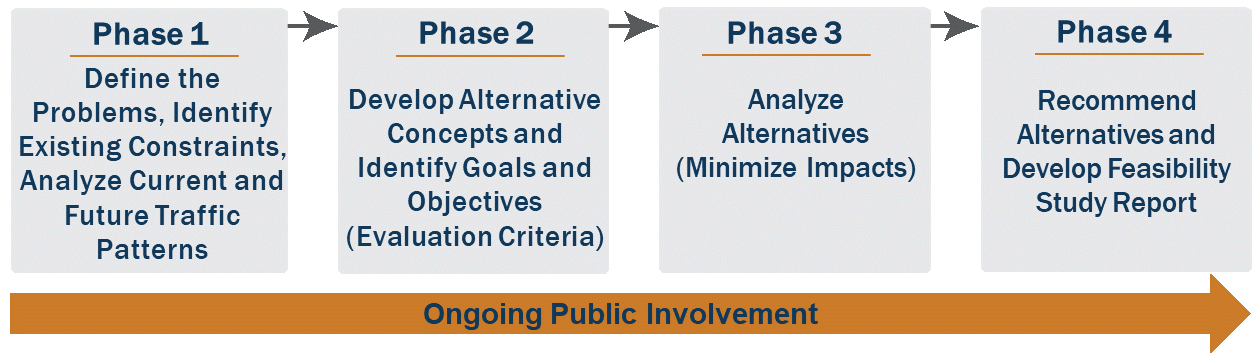
A feasibility study is a multiphase process that develops and examines different alternatives for a proposed project or projects. A feasibility study begins by evaluating existing conditions in the area and identifying goals and objectives. Alternative concepts are proposed and analyzed. Recommended improvements are based on several factors, including the minimization of potential impacts to natural and cultural resources. Throughout the feasibility study, there are many opportunities for the public to provide input. For the US 281 feasibility study, the team will provide opportunities for the community to provide feedback on:
- Existing constraints
- Improvements needed
- Current and future concerns
- Preferred alignment
- Additional considerations for study team
- Study recommendations
Project background
Due to high travel demand, US 281 congestion within the city of Hamilton located in Hamilton County continues to increase, but space is limited in Hamilton’s downtown square district to add US 281 travel relief lanes.
The Relief Route project involves:
- Data collection and an inventory of existing transportation system features (including traffic origin and destination data, operating conditions, and safety issues)
- Analysis of current and future traffic forecasts and travel demand modeling
- Development of the purpose and need statement and project goals
- Development of inventory of environmental and community features
- Development of alternative improvements and preliminary cost estimates
- Identification of future transportation improvement projects
- Evaluation of potential impacts and cost-benefit analysis for proposed improvements
Proposed improvements
The project would be approximately 16.7 miles in length. The proposed Hamilton Truck / Relief Route would be a four-lane divided roadway with non-continuous two-lane frontage roads and access ramps to major cross-streets. The proposed Hamilton Truck / Relief Route would require additional right of way to accommodate the construction of the project. Environmental studies are ongoing to determine the environmental impacts associated with constructing the Truck / Relief Route.
Additional information
Prior to this project, the Waco District initiated a US 281 Truck / Relief Route Feasibility Study to explore and evaluate added capacity and operational improvements to US 281 to alleviate congestion along the entire roadway within Hamilton County from the city of Hico southward to the city of Evant. This study conducted three advertised Public Meetings.
Multiple Route Alignments were explored, evaluated, and presented during the US 281 Feasibility Study at three advertised public meetings. TxDOT also met with interested agencies, stakeholders, and landowners.
Next steps
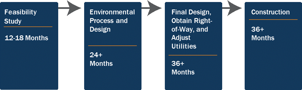
The US 281 Truck/ Relief Route Project’s currently anticipated Let Date is December 2029.
The total estimated project cost for the project is to be determined. The project is currently unfunded for construction and cannot let until funding is identified; however, right of way acquisition can proceed even if the project is not funded for construction.
CSJ(s): 0251-01-064, 0251-02-050, and 0183-03-054