I-20 Widening Project at FM 1788
Skip to main content

I-20 Widening Project at FM 1788

Project overview

Current construction involves the demolition of the existing bridge on FM 1788 and the construction of a new I-20 bridge over FM 1788. With the demolition of the FM 1788 bridge, FM 1788 will cross below the I-20 mainlanes, and a new bridge will carry I-20 over FM 1788. Updated construction details include a change from hot mix asphalt to concrete pavement to extend pavement life, and localized drainage improvements to achieve positive flow.

These improvements will:

  • Enhance operation and safety
  • Reduce traffic congestion
  • Improve roadway connectivity along the I-20 corridor

The project, which began in fall of 2026, is expected to take 12 - 14 months, with completion in early 2028.

Proposed improvements

The proposed project would include the demolition of the existing bridge on FM 1788 and the construction of a new I-20 bridge over FM 1788. Improvements would address:

  • Adding additional main lanes
  • Constructing new interchanges
  • Reconfiguring ramps
  • Converting frontage roads from two-way operation to one-way operation
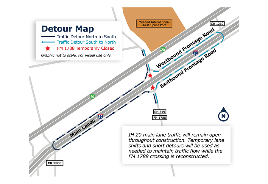
The map depicts the I-20 and FM 1788 interchange near Midland International Air & Space Port in Midland County, Texas. Dark blue arrows indicate the detour route for northbound-to-southbound traffic, while light blue arrows indicate the detour route for southbound-to-northbound traffic. Two red star symbols mark locations where FM 1788 is temporarily closed at the I-20 crossing. Traffic is directed onto the westbound and eastbound frontage roads to bypass the closure. The map identifies nearby roads including SH 349, CR 1260, and CR 1300. A note on the graphic states that I-20 main lane traffic will remain open throughout construction and that temporary lane shifts and short detours will be used as needed to maintain traffic flow while the FM 1788 crossing is reconstructed. The graphic is not to scale and is intended for visual reference only.
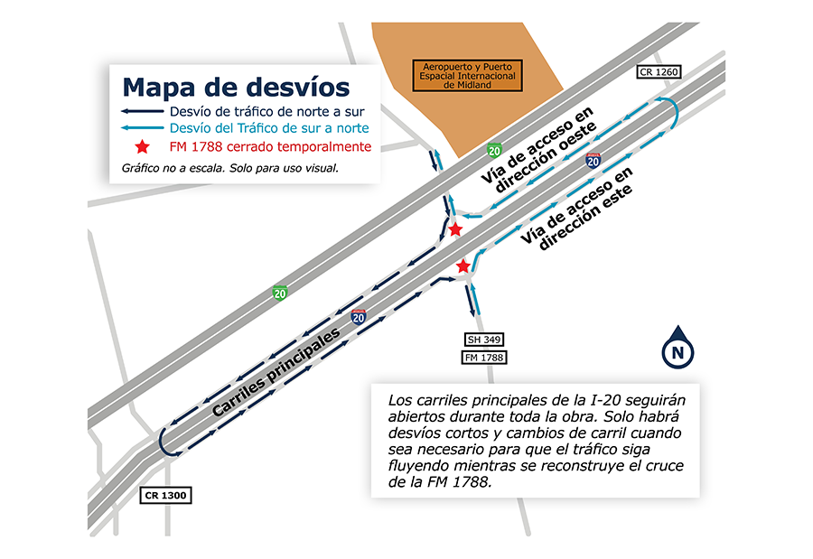
Gráfico informativo titulado “Mapa de desvíos”. El mapa ilustra la zona de la I-20 y FM 1788 cerca del Aeropuerto y Puerto Espacial Internacional de Midland. Dos estrellas rojas indican puntos donde FM 1788 estará temporalmente cerrada. Flechas azul oscuro muestran el desvío para el tráfico que viaja de norte a sur, y flechas azul claro muestran el desvío para el tráfico que viaja de sur a norte utilizando las vías de acceso este y oeste de la I-20. El mapa también identifica las carreteras SH 349, CR 1260 y CR 1300. Una nota informa que los carriles principales de la I-20 permanecerán abiertos durante toda la construcción y que solo habrá cierres breves o cambios de carril cuando sea necesario para mantener el flujo del tráfico mientras se reconstruye la intersección de FM 1788. El gráfico no está a escala y es solo para uso visual.

Downloads