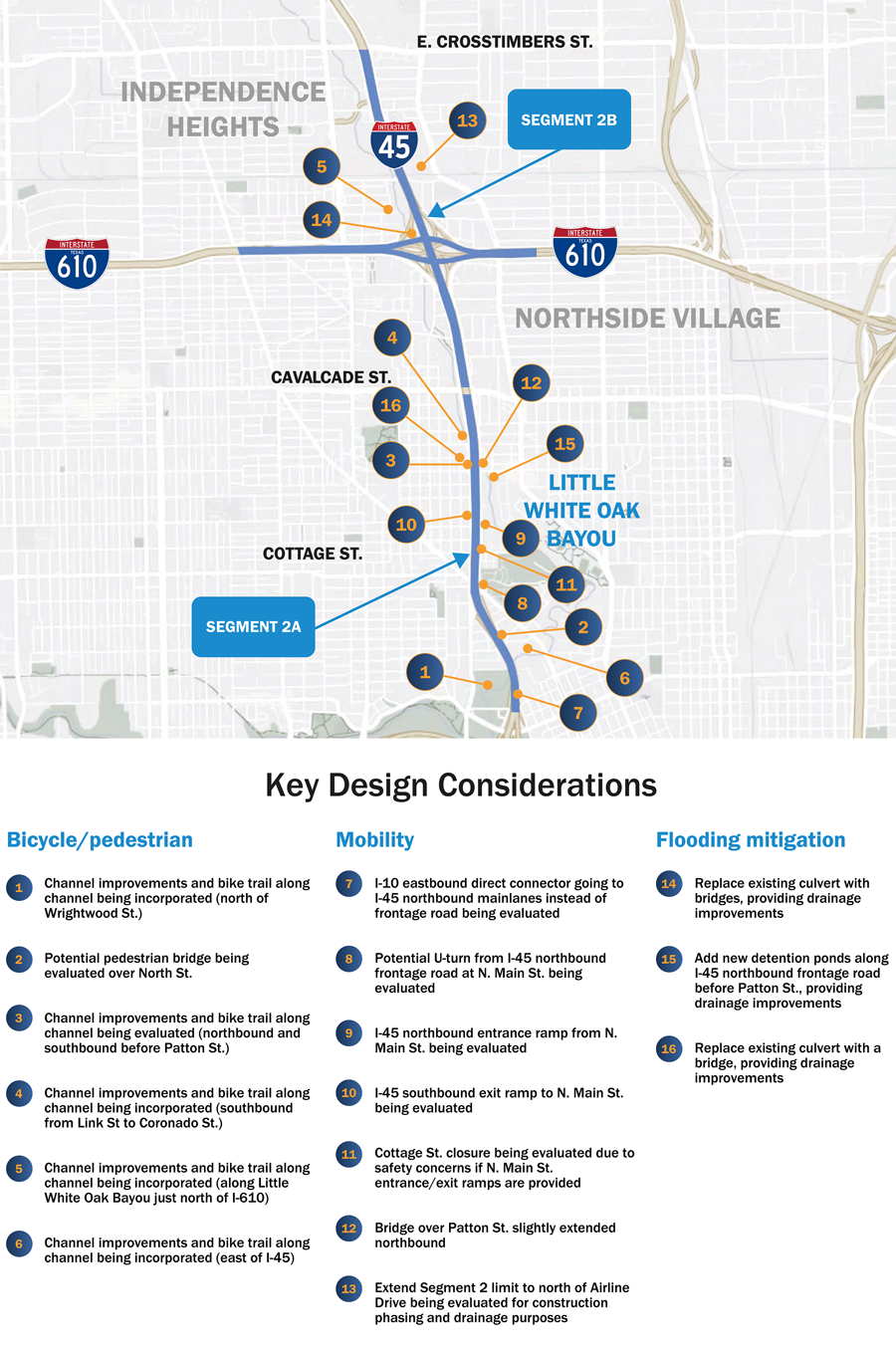
Project segments
Key information
This segment will improve the I-45 mainlanes and frontage roads from I-10 north to I-610 and rebuild the I-45/I-610 interchange
- Widen I-45 in this area to accommodate four MaX (Managed Express) lanes. The proposed roadway would include ten general purpose lanes (five in each direction), four MaX lanes (two in each direction), and two to three frontage road lanes in each direction.
- The MaX lanes would increase the High Occupancy Vehicle) space in the middle of the I-45 mainlanes from one lane to four. Only buses and vehicles with two or more people in them would be able to travel in the MaX lanes.
- The proposed I-45 and I-610 frontage roads would be continuous at the I-45/I-610 interchange.
- The mainlanes will be depressed between Cottage and N. Main streets, providing an opportunity to build a structural cap which could be funded and developed by others.
- TxDOT is studying how to potentially reduce the roadway footprint of this project.
- I-45 NHHIP proposes significant drainage improvements in accordance with new Atlas 14 standards issued by NOAA.
Construction phasing
Project Funding
Total Cost = $1,620,200,000
Bicycle/pedestrian
1.)
Channel improvements and bike trail along channel being incorporated (north of Wrightwood St.)
2.)
Potential pedestrian bridge being evaluated over North St.
3.)
Channel improvements and bike trail along channel being evaluated (northbound and southbound before Patton St.)
4.)
Channel improvements and bike trail along channel being incorporated (southbound from Link St to Coronado St.)
5.)
Channel improvements and bike trail along channel being incorporated (along Little White Oak Bayou just north of I-610)
6.)
Channel improvements and bike trail along channel being incorporated (east of I-45)
Mobility
7.)
I-10 eastbound direct connector going to I-45 northbound mainlanes instead of frontage road being evaluated
8.)
Potential U-turn from I-45 northbound frontage road at N. Main St. being evaluated
9.)
I-45 northbound entrance ramp from N. Main St. being evaluated
10.)
I-45 southbound exit ramp to N. Main St. being evaluated
11.)
Cottage St. closure being evaluated due to safety concerns if N. Main St. entrance/exit ramps are provided
12.)
Bridge over Patton St. slightly extended northbound
13.)
Extend Segment 2 limit to north of Airline Drive being evaluated for construction phasing and drainage purposes
Flooding mitigation
14.)
Replace existing culvert with bridges, providing drainage improvements
15.)
Add new detention ponds along I-45 northbound frontage road before Patton St., providing drainage improvements
16.)
Replace existing culvert with a bridge, providing drainage improvements
Potential footprint reduction
TxDOT remains committed to evaluating reasonable opportunities to reduce the project footprint in ways that would not compromise the Purpose and Need of the project, as described in the Record of Decision (ROD). In Segment 2, TxDOT is evaluating whether the project footprint can be reduced along I-45 northbound between North St. and North Main St. as shown in the image to the left.
ROW reduction methodology & guidelines
- Meets Project Purpose and Need as stated in Record of Decision (ROD)
- No design exceptions
- No reduction in capacity
- Consider braided ramps where applicable
- Braided ramps are where the exit/entrance ramps are in the same space, with one over the other
- No elevated MaX lanes
- Minimum 20-foot border width on frontage roads
- All frontage roads to include bicycle/pedestrian facilities (no on-street bicycle facilities allowed)
- Potential sound wall locations
- Evaluate different ramp widths to reduce right of way widths
Segment improvements
Independence Heights
- Dark yellow area on map shows where Independence Heights has routinely flooded
- I-45 NHHIP proposes to replace drainage culverts with bridges, providing drainage improvements
- This area would be removed from the floodplain
Drainage improvements
- 14 additional detention ponds, 42% greater capacity than required
- Increase in underground pipe capacity to take floodwater to detention ponds and pump stations
- Improvements along White Oak Bayou and Little White Oak Bayou will remove flooding from yellow area on map
Segment 2 - 3D Schematics Visualization
(Video Transcript)
Segment 2
This visualization shows the proposed I-45 from the I-10/Quitman Street area including the
I-610 interchange, moving southbound to northbound. An area of I-45 between Main and Cottage streets is proposed to be depressed. The structural cap on top could be developed by parties other than TxDOT into a public space.
In this area, the I-45 North Houston Highway Improvement Project, or NHHIP, would widen the roadway to accommodate four lanes known as Max lanes. The roadway would have five general purpose lanes in each direction, with full-width shoulders added. In the middle would be two Max lanes in each direction, operating 24 hours a day, seven days a week carrying High Occupancy Vehicle, or HOV, traffic.
Currently, the limited HOV system in this area consists of one reversible lane, which takes traffic inbound in the mornings and outbound in the evenings. Along the frontage roads, bicycle-pedestrian features would also be added.
At the I-610 interchange, continuous frontage roads would be built along both I-45 and I-610. The current left exits to the direct connectors at the interchange would be replaced by exits on the right side of the roadway.


