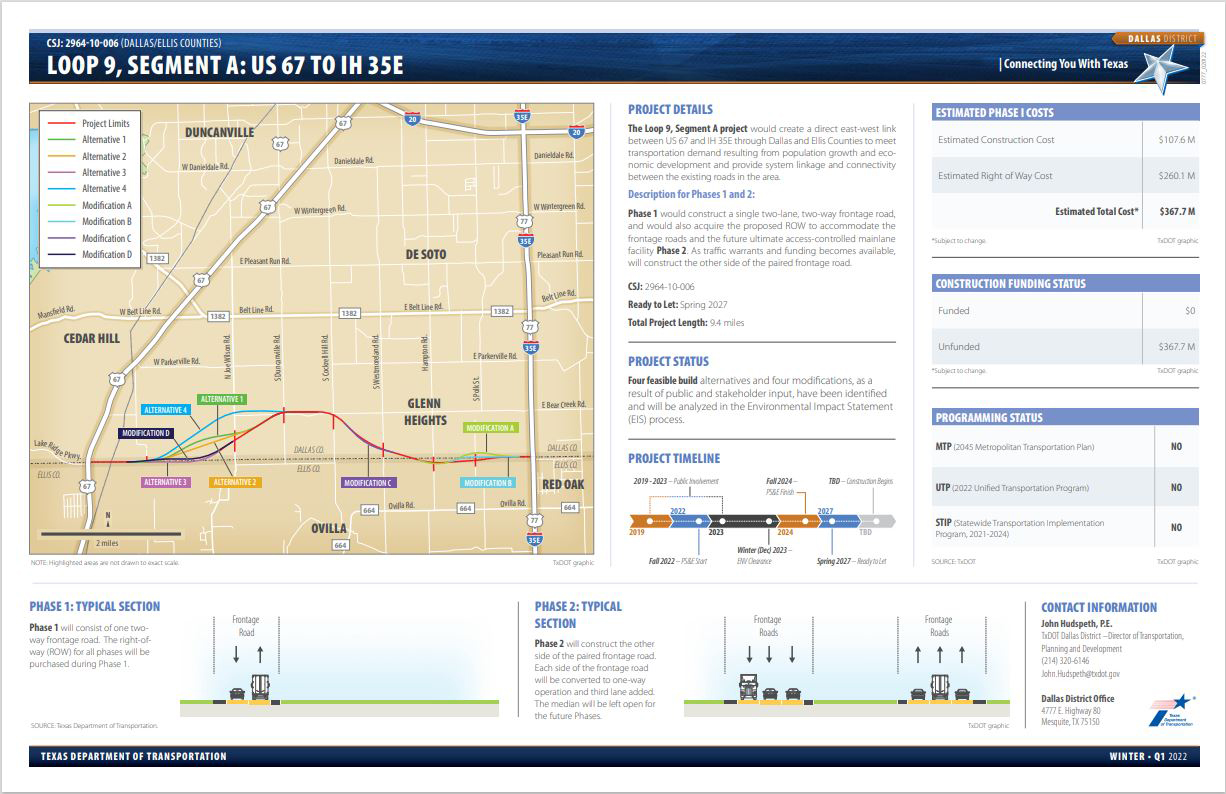
The proposed Loop 9, Segment A project is an approximately 9.4 mile proposed new location, six-lane roadway within Dallas and Ellis Counties. Loop 9, Segment A would include an eastbound and westbound frontage road facility, each consisting of three 12-foot lanes, an 8-foot inside shoulder and an 8-foot outside shoulder. The proposed project right-of-way (ROW) would include a median that would accommodate the future construction of an ultimate access-controlled mainlane facility. Additionally, a 10-foot wide berm has been preserved on either side of the proposed ROW to accommodate a future shared use path. The proposed project passes through the cities of Cedar Hill, Ovilla, Glenn Heights and Red Oak.
- Loop 9, Segment A - Final Environmental Impact Statement and Record of Decision
As part of the NEPA process, TxDOT evaluated various project alternatives and modifications including the No-Build Alternative. After completing a very detailed evaluation, TxDOT selected Alternative 3 with Modifications D, C and B as its Recommended Preferred Alternative for the project.
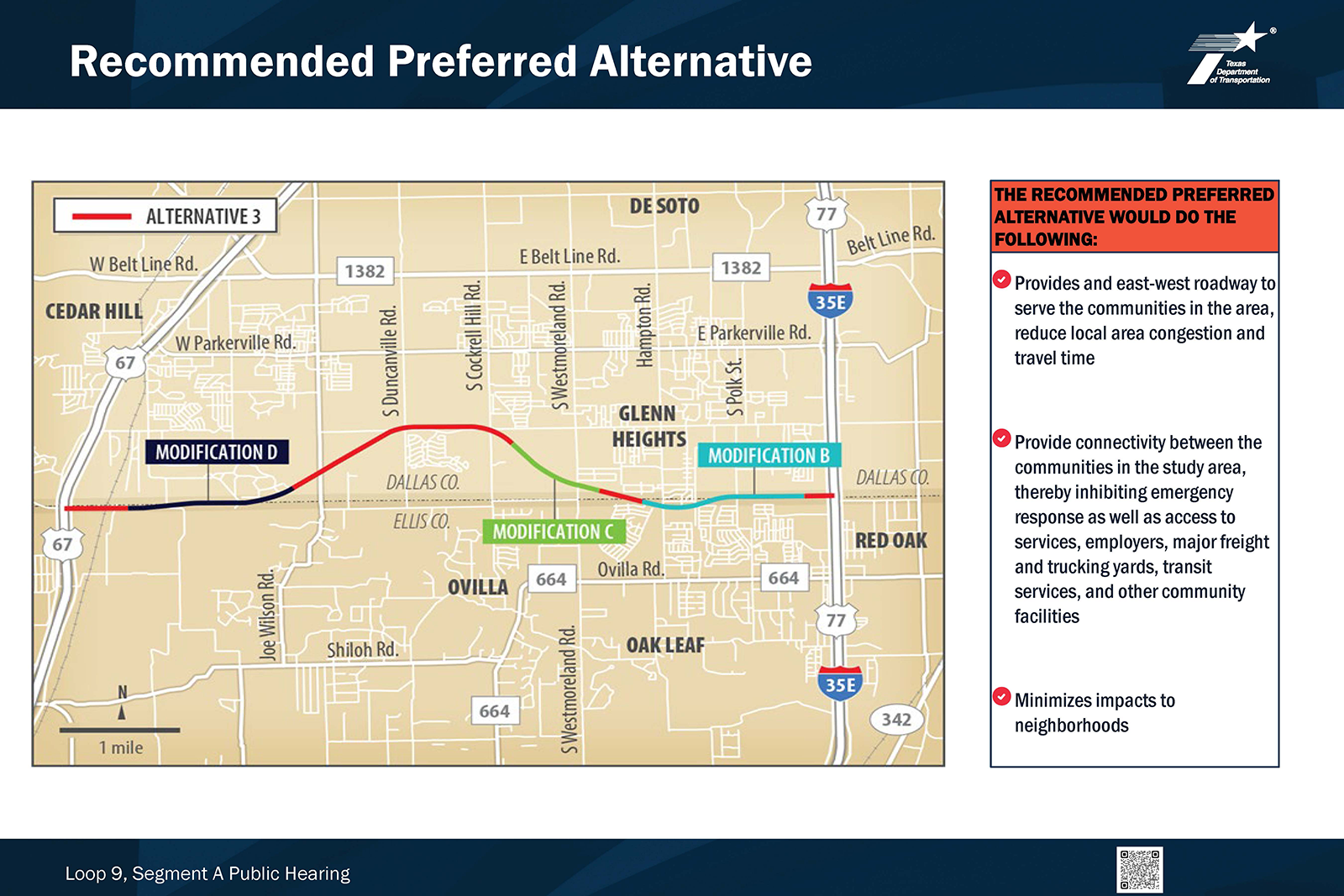
The proposed project would construct intersections at eight major cross roads as follows: Tar Road, future Clark Road, S. Joe Wilson Road, S. Duncanville Road, S. Cockrell Hill Road, S. Westmoreland Road, S. Hampton Road, and Uhl Road. The proposed project would also construct a grade separation at the BNSF Railroad. In addition, the western limit of the project would tie into a grade separation at US 67 which would be constructed under a separate project prior to the construction of Loop 9, Segment A. The eastern limit of the project would tie into a grade separation at IH 35E, which would be constructed under a separate project prior to the construction of Loop 9, Segment A.
The proposed Loop 9 frontage road project, from US 67 to IH 35E, would likely be constructed in two phases based on traffic needs and project funding. A logical sequence for staging the various elements for the construction of the new location frontage road system could be as follows:
- Phase 1 - Construct only one two-way frontage road while purchasing the entire proposed ROW for the ultimate facility.
- Phase 2 - Construction of the three-lane frontage road in each direction, which would include the conversion of the two-way frontage road built in Phase 1 to a one-way operation. Grade separations at specific high-volume intersections would also be constructed during this phase.
- Phase 3 - Construction of the ultimate access-controlled mainlane facility.
Frequently asked questions
Construction of the frontage road improvements would require additional ROW. Each build alternative concept would require differing amounts of ROW. The No Build Alternative is also an option.
It is anticipated that the proposed project would result in potential displacement of residences and businesses. The actual number of potential displacements of residential structures, businesses, and facilities will be determined during the FEIS process by reviewing existing aerial photographs, land use maps, and conceptual engineering drawings. Also, a number of utilities are expected to require relocation and/or realignment for compatibility with the proposed project facility.
Consistent with U.S. Department of Transportation policy, as mandated by the Surface Transportation and Uniform Relocation Assistance Act of 1987, TxDOT provides relocation resources to all displaced persons without discrimination. All property owners from whom property is needed are entitled to receive just compensation for their land and property. Just compensation is based upon the fair market value of the property. TxDOT also provides, through its Relocation Assistance Program, payment and services to aid in movement to a new location.
The proposed Loop 9 frontage road project, from US 67 to IH 35E, would likely be constructed in two phases based on traffic needs and project funding. A logical sequence for staging the various elements for construction of the new location frontage road system could be as follows:
- Phase 1 - Construct only one two-way frontage road while purchasing the entire proposed ROW for the ultimate facility.
- Phase 2 - Construction of the three-lane frontage road in each direction, which would include the conversion of the two-way frontage road built in Phase 1 to a one-way operation. Grade separations at specific high-volume intersections would also be constructed during this phase.
- Phase 3 - Construction of the ultimate access-controlled mainlane facility.
Phase 1 could begin as early as 2027 but is still “To-be-Determined”. Construction of Phase 1 would take approximately 3 years. Construction for Phase 2 (the three-lane frontage road in each direction) and Phase 3 (ultimate access-controlled mainlane facility in both directions) will be determined based on projected traffic and available funding (as warranted).
The estimated total cost for Phase I of the project is $342 million.
Construction of Phase 2 (the three-lane frontage road in each direction) and Phase 3 (future phasing - ultimate access-controlled mainlane facility in both directions) will be determined based on projected traffic and funding availability (as warranted). At that time, cost estimates will be developed based on the current market values.
Any future construction may require alteration of access and driveways. However, access to adjacent property sites would be maintained through all phases of the construction.
Loop 9 Segment A would provide an 8-foot inside shoulder and 8-foot outside shoulder along the frontage roads for bicycle accommodations. The improvements also include 10-foot wide berm along the proposed ROW to accommodate future bicycle and pedestrian facilities.
Portions of the proposed project would be located within the 100-year floodplain and the floodway. However, the proposed project would not increase the base flood elevation to a level that would violate applicable floodplain regulations and ordinances. If necessary, mitigation would be provided through the construction of detention ponds.
Contact information
Maps and documents
Loop 9, Segment A download map (118 bytes)
Public hearings
In-person public hearing
Thursday, Dec. 8, 2022
5:30 p.m. – 7:30 p.m.
Alan E. Sims Cedar Hill Recreation Center
310 E. Parkerville Road
Cedar Hill, TX 75104
In-person public hearing
Tuesday, Dec. 13, 2022
5:30 p.m. – 7:30 p.m.
The Hamptons Event Venue
196 N. I-35E
Red Oak, TX 75154
Virtual public hearing
Thursday, Dec. 8, 2022 5:30 p.m. through Tuesday, Jan. 3, 2023, at 11:59 p.m.
Public Hearing for Loop 9, Segment A
Note: This is not a live event
Prior public meetings
Segment A from US 67 to IH 35E
Feb. 6 and 13, 2020 | 6-8 p.m.
| Prior Public Meetings Information |
| Notice (PDF: 0.04Mb) |
| Notice (Español) (PDF: 0.04Mb) |
| Venue Location Map (PDF: 0.45Mb) |
Segment A from US 67 to IH 35E
March 2 and 3, 2022
5:30 p.m. - 7.30 p.m.
| Title |
| Notice |
| Notice (Español) |
Public scoping meeting
Segment A from US 67 to IH 35E
Tuesday, July 9, 2019 | 6-8 p.m.
Red Oak Municipal Center 200 Lakeview Parkway
Red Oak, TX 75154
Agency scoping meetings
Segment A from US 67 to IH 35E
Thursday, July 11, 2019 | 6-8 p.m.
Cedar Hill Recreational Center 310 East Parkerville Road
Cedar Hill, Tx 75104
Segment A from US 67 to IH 35E
Aug. 8, 2019
TxDOT Dallas District Office
4777 E. Highway 80
Mesquite, Tx 75150
Gallery