The need for these improvements is to address population growth, transportation demand, system linkages, and connectivity among existing roadway facilities.
Loop 9 would provide a direct east-west transportation link from US 67 to I-20, accommodate expanding transportation demands, increase mobility and accessibility in the region, reduce travel times, and support economic development opportunities for residents and businesses in the area.
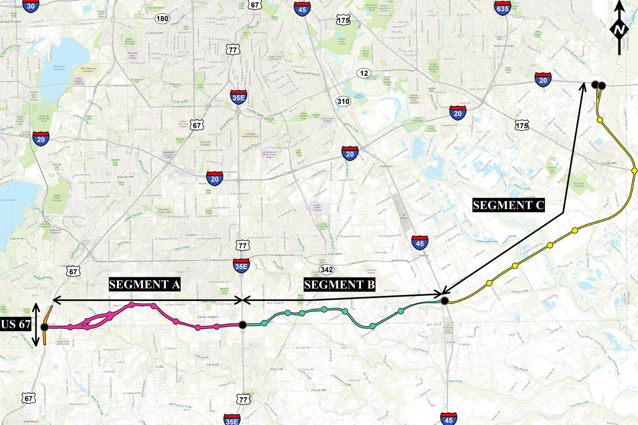
Loop 9 is located in the Dallas-Fort Worth (DFW) metropolitan area of north central Texas. The majority of Loop 9 lies in southern Dallas County and northern Ellis County, with a small portion of the eastern end in northwestern Kaufman County. The proposed Loop 9 project begins at US 67 near Cedar Hill and extends east to I-20 near Seagoville. The proposed project right-of-way (ROW) would include a median that would accommodate the future construction of an ultimate access- controlled mainlane facility. Construction of the ultimate access-controlled mainlane facility would be based on projected traffic and funding and would require additional environmental analysis prior to construction.
Loop 9 overview map
Details
Loop 9 is located in the Dallas-Fort Worth (DFW) metropolitan area of north central Texas. The majority of Loop 9 lies in southern Dallas County and northern Ellis County, with a small portion of the eastern end in northwestern Kaufman County. The proposed Loop 9 project begins at US 67 near Cedar Hill and extends east to I-20 near Seagoville. The proposed project right-of-way (ROW) would include a median that would accommodate the future construction of an ultimate access- controlled mainlane facility. Construction of the ultimate access-controlled mainlane facility would be based on projected traffic and funding and would require additional environmental analysis prior to construction.
First conceived in 1957, the concept of an “Outer Loop” freeway around the Dallas metropolitan area was introduced in 1964 by the Greater Dallas Planning Council’s Regional Transportation Highway Plan. In 1964, the Texas Highway Commission authorized this outer loop around Dallas and identified and designated it as a freeway facility to be known as Loop 9 pursuant to a Regional Transportation Highway Plan.
Although never finalized, the Loop 9 Feasibility and Route Alignment Study was authorized by Dallas County in 1995. In 1997, study efforts resulted in a “Technically Preferred Alignment” that was approved and/or adopted by many of the cities and agencies involved in the study. However, study efforts were temporarily suspended before a “Locally Preferred Alignment” was identified.
In May 2002, the Loop 9 Feasibility Study was reinitiated to identify viable corridor alignments and modal alternatives for the study corridor. From 2002 to 2006, alignment and environmental constraints, coupled with the growth and desires of surrounding communities resulted in further alignment revisions to avoid and minimize impacts.
By 2006, a possible connection between the Loop 9 project and other statewide transportation improvements required Loop 9 stakeholders to consider substantial design modifications so that the project would conform to the highest-speed TxDOT roadway design criteria. Between 2006 and 2011, TxDOT prepared the Loop 9 Southeast Preliminary Draft Environmental Impact Statement (DEIS) and associated concept designs. While these studies were under review by the Federal Highway Administration (FHWA), several changes in transportation planning occurred in Texas and within the region. TxDOT changed how they intended to advance large corridor transportation projects and removed the Trans-Texas Corridor from statewide transportation plans. Second,North Central Texas Council of Governments (NCTCOG) released a new regional demographic forecast showing that population growth would be slower in the Loop 9 Southeast study area. Third, they published the Regional Outer Loop Feasibility Study Report, which did not recommend an outer loop in the Dallas/Fort Worth metropolitan area. These factors contributed to the decision to move the Loop 9 project in a different direction. The DEIS study was put on hold in November 2011 and was officially stopped in January 2012.
The FHWA, in cooperation with TxDOT, originally published a NOI in the Federal Register on August 2, 2002 (Volume 67, No.149, Page 50504), and a NOI revision was made on January 20, 2004 (Vol. 69, No. 12, Page 2809) to prepare an EIS for Loop 9 from US 287 to IH 20 in Dallas and Ellis Counties. TxDOT had been actively working on the Loop 9 Southeast project from US 287 to IH 20 by developing an EIS and associated project schematics. However, (and as mentioned earlier) changes had occurred in TxDOT policy, funding constraints for transportation projects, and the current economic climate which impacted the assumptions and development of the RTC approved Mobility 2035: The Metropolitan Transportation Plan for North Central Texas (Mobility 2035). NCTCOG had completed the updated 2035 Metropolitan Transportation Plan for the region and determined that there was a significant reduction in the travel demand for the Loop 9 project. The reduction in projected traffic was shown to be a result of the retirement of the Texas Trans Corridor concept and change in the regional growth projections in the study area. For these reasons, the Loop 9 project would no longer be under consideration as originally planned. These changes specifically impacted the Preliminary Loop 9 Southeast Draft Environmental Impact Statement and work efforts were suspended until a determination on how the project should proceed was made. As a result, FHWA issued a notice to advise the public that the NOI to prepare an EIS for proposed Loop 9 from US 287 to IH 20 was rescinded.
TxDOT, NCTCOG, and local leaders began working together to develop a plan to identify a new direction for the project corridor. An overview of the plan was presented to the FHWA staff on September 13, 2012 via a conference call. The discussion resulted in the following decision: “Following the Feasibility study, and based on logical termini, proceed with EA(s) for priority segments of independent utility to allow for purchase of right-of-way and construction of non-controlled access facility while allowing the flexibility for future grade separations and/or main lanes; and that future grade separations and main lanes would require additional environmental document”.
In September 2012, a Loop 9 Corridor/Feasibility Study began for the revised Loop 9 project concept from US 67 to I-20. The Feasibility Study follows the Planning and Environment Linkages (PEL) approach to help evaluate environmental issues early in the planning process. The Feasibility Study incorporates more flexible design standards, a reduced right-of-way (ROW), and a shorter project length. The project would be more closely aligned with the transportation and development needs of the southeast Dallas region. The ultimate goal of the Feasibility Study was to develop a program of independent projects to advance into the National Environmental Policy Act (NEPA) process based on mobility needs, engineering and environmental data, and coordination with NCTCOG, local officials, the public, and resource agencies.
September 2013 - Corridor/Feasibility Study
September 24 and 26, 2013
- Summary Report (PDF: 0.46Mb) (118 bytes)
- Comment Form (PDF: 0.08Mb) (118 bytes)
- Presentation (PDF: 4.8Mb) (118 bytes)
- Project Fact Sheet (PDF: 1.3Mb) (118 bytes)
- Information Boards (PDF: 3.7Mb) (118 bytes)
- Constraints Maps: Map 1 (PDF: 7Mb) (118 bytes) Map 2 (PDF: 6.6Mb) (118 bytes) Map 3 (PDF: 6Mb) (118 bytes) Map 4 (PDF: 7.4Mb) (118 bytes) Map 5 (PDF: 7.2Mb) (118 bytes)
- Map 6 (PDF: 7Mb) (118 bytes)
- Corridor Maps: Map 1 (PDF: 13Mb) (118 bytes) Map 2 (PDF: 11Mb) (118 bytes) Map 3 (PDF: 10Mb) (118 bytes) Map 4 (PDF: 11Mb) (118 bytes)
May 2013 - Corridor/Feasibility Study
May 16 and 23, 2013
- Summary Report (PDF: 0.46Mb) (118 bytes)
- Comment Form (PDF: 0.08Mb) (118 bytes)
- Comment Map Handout (PDF: 0.08Mb) (118 bytes)
- Presentation (PDF: 4.8Mb) (118 bytes)
- Project Fact Sheet (PDF: 1.3Mb) (118 bytes)
- Information Boards (PDF: 3.7Mb) (118 bytes)
- Constraints Maps: Map 1 (PDF: 7Mb) (118 bytes) Map 2 (PDF: 6.6Mb) (118 bytes) Map 3 (PDF: 6Mb) (118 bytes) Map 4 (PDF: 7.4Mb) (118 bytes) Map 5 (PDF: 7.2Mb) (118 bytes) Map 6 (PDF: 7Mb) (118 bytes)
- Corridor Maps: Map 1 (PDF: 13Mb) (118 bytes) Map 2 (PDF: 11Mb) (118 bytes) Map 3 (PDF: 10Mb) (118 bytes) Map 4 (PDF: 11Mb) (118 bytes)
Previous public involvement materials can also be found at: Keep it Moving Dallas under “Public Hearings/Meetings” and on TxDOT.
Loop 9 Corridor
Feasibility Study files
Use the links below to access the Corridor Feasibility Study Files. Due to the large file sizes, each link connects to a separate part of the document in order to reduce downloading time.
- Loop 9 Southeast Corridor Feasibility Study (PDF: 7Mb)
- Exhibit 1: Environmental Constraints Map (PDF: 16Mb)
- Appendix A: FHWA PEL Questionnaire (PDF: 2Mb)
- Appendix B: State and Federal Resource Agency Webinar Summary (PDF: 3Mb)
- Appendix C: Local Government Interviews and Meeting Summaries (PDF: 40Mb)
- Appendix D: Regional Task Force Meeting Summaries (PDF: 11Mb)
- Appendix E: Major Stakeholder Meeting Summaries (PDF: 5Mb)
- Appendix F: Public Meeting Summaries (PDF: 1.5Mb)
- Appendix G: Record of Comments Received and Responses (PDF: 2Mb)
- Appendix H: Traffic Analysis Memorandum (PDF: 8Mb)