The 2013 Regional Goods Movement Plan completed by the Houston-Galveston Area Council (H-GAC), indicated a need to route traffic around the west side of Houston’s Urban Core to provide adequate facilities for north/south freight movement, system linkage and connectivity. Such a facility would also provide enhanced emergency evacuation opportunities.
The concept shown generally followed existing SH 36 from Freeport north to Rosenberg then northward through Fort Bend and Waller counties to US 290/SH 6 north of Hempstead. The recommendations of this plan were incorporated into H-GAC’s 2040 Regional Transportation Plan (RTP).
H-GAC along with stakeholders involved in the Regional Goods Movement Plan realized that the proposed concept would complement the needs identified locally for north-south mobility in the fast-growing areas southwest of Houston. The Highway 36A Coalition, consisting of local governments, elected officials, private businesses and individuals, was formed to advocate for improved mobility and goods movement through Brazoria, Fort Bend and Waller Counties.
With the Highway 36A Coalition’s advocacy and with the support of the H-GAC’s Transportation Policy Council, H-GAC provided funding for the initial phase of an environmental study. The Texas Department of Transportation (TxDOT) agreed to advance the study of a proposed new location highway from SH 36 south of Needville (southwest of Rosenberg), northward to US 290/SH 6 north of Hempstead, approximately 66 miles, using, in part, the funds appropriated by H-GAC.
Preliminary activities
The preliminary concept for proposed 36A is envisioned as a new controlled access transportation facility. The TxDOT Houston District (HOU) began preliminary work on the 36A project in 2018. Since that time, the HOU district has developed a draft Purpose and Need statement, draft Project Coordination and Public Involvement Plan, and a draft Alternatives Development and Screening Methodology. The project will be formally initiated with the publication of a Notice of Intent (NOI) in the Federal Register for each independent portion of the project, as discussed below.
Pre-NOI meetings have been held with multiple stakeholders in the Study Area, including Austin County, Fort Bend County, Harris County and Waller County, as well as with major landowners and public interest groups such as the Greater Fort Bend Economic Development Council and the Katy Prairie Conservancy. Through this outreach, the project team received comments regarding the draft project study area, the draft proposed Purpose and Need and major development constraints to be considered.
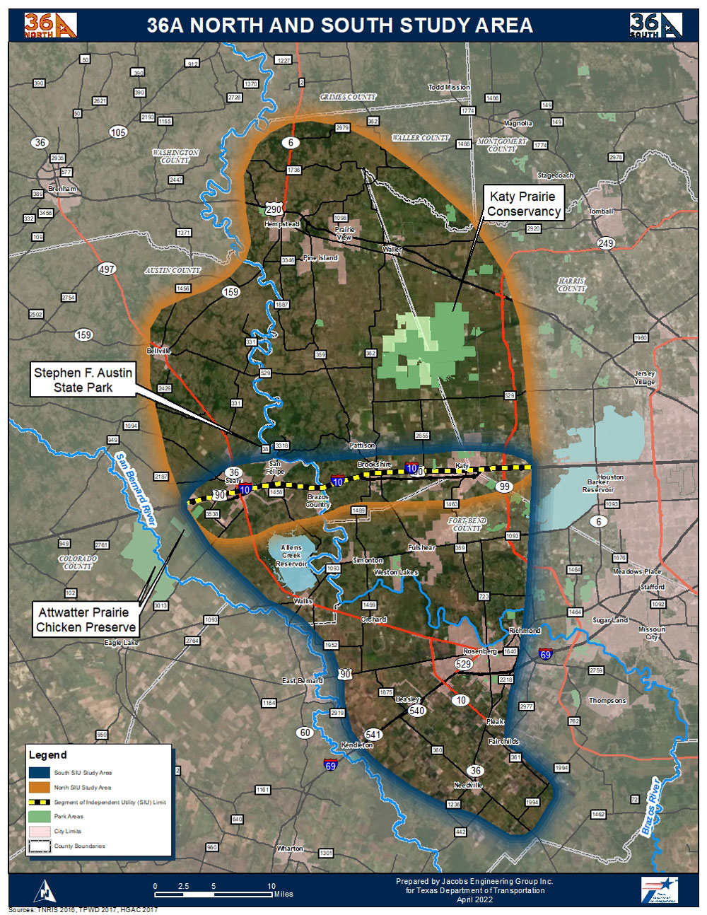
Segments of Independent Utility (SIU)
As a result of early outreach, stakeholders requested this project be split into two segments and the southern terminus be adjusted to SH 36 south of Needville, and the northern terminus remain 290/SH 6 north of Hempstead, increasing the overall project length from 55 miles to approximately 66 miles, 30 miles for the northern segment and 36 miles for the southern segment.
While this proposal would separate the larger project into two seperate SIUs, HOU believes the integrity of the environmental analysis will not be compromised. As the SIU designation suggests, both projects can function independently to meet their individual purpose and need without the necessity of the other project. Environmental review and clearance under the National Environmental Policy Act (NEPA) for the proposed 36A corridor would be accomplished through preparation of separate EIS’s for each of these SIUs. HOU believes this separation will have the benefit of allowing each SIU to progress independent of the other, on their own schedules and allow focus and flexibility in addressing the unique issues, concerns or constraints of each of the SIUs without compromising the integrity of the environmental analysis. Should either of these SIUs not proceed to construction, the adjacent project could well proceed as an independent, functional roadway.
The 2013 Regional Goods Movement Plan completed by the Houston-Galveston Area Council (H-GAC), indicated a need to route traffic around the west side of Houston’s Urban Core to provide adequate facilities for north/south freight movement, system linkage and connectivity. Such a facility would also provide enhanced emergency evacuation opportunities. The concept shown generally followed existing SH 36 from Freeport north to Rosenberg then northward through Fort Bend and Waller counties to US 290/SH 6 north of Hempstead. The recommendations of this plan were incorporated into H-GAC’s 2040 Regional Transportation Plan (RTP).
H-GAC along with stakeholders involved in the Regional Goods Movement Plan realized that the proposed concept would complement the needs identified locally for north-south mobility in the fast-growing areas southwest of Houston. The Highway 36A Coalition, consisting of local governments, elected officials, private businesses and individuals, was formed to advocate for improved mobility and goods movement through Brazoria, Fort Bend and Waller Counties.
With the Highway 36A Coalition’s advocacy and with the support of the H-GAC’s Transportation Policy Council, H-GAC provided funding for the initial phase of an environmental study. TxDOT agreed to advance the study of a proposed new location highway from SH 36 south of Needville (southwest of Rosenberg), northward to US 290/SH 6 north of Hempstead, approximately 66 miles, using, in part, the funds appropriated by H-GAC.