Project overview
The proposed 36A project is envisioned as a new controlled access transportation facility.
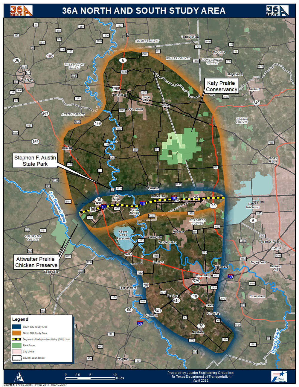
The Texas Department of Transportation (TxDOT) Houston District (HOU) is preparing studies for a potential highway corridor connecting SH 36 South of Needville (southwest of Rosenberg), northward to US 290/SH 6 North of Hempstead, approximately 66 miles. Two segments of independent utility (SIUs) are proposed, as described below. The anticipated scale of these projects is such that preparation of Environmental Impact Statements (EISs) will be required under the National Environmental Policy Act (NEPA).
The environmental review, consultation and other actions required by applicable Federal environmental laws for this project are being, or have been, carried out by TxDOT pursuant to 23 USC 327 and a Memorandum of Understanding (MOU) dated Dec. 9, 2019, executed by the Federal Highway Administration (FHWA) and TxDOT. This MOU assigns to TxDOT FHWA’s responsibilities under NEPA and other environmental laws. Therefore, TxDOT is preparing EISs for two SIUs in its role as the lead federal agency under the MOU between TxDOT and FHWA.
Throughout the development of these projects, TxDOT will host a series of meetings to gather feedback for the 36A project and/or a specific SIU (36A South and/or 36A North). Formal public hearings will be held upon completion of each Draft EIS.
A number of meetings have been held with multiple stakeholders in the Study Area, including Austin County, Fort Bend County, Harris County and Waller County, as well as with major landowners and public interest groups such as the Greater Fort Bend Economic Development Council and the Katy Prairie Conservancy. Through this initial outreach, the project team received comments regarding the proposed purpose and need of the project and major development constraints to be considered. This effort is prior to the formal release of the Notice of Intent (NOI) in the Federal Register and as such is described as Pre-NOI. The publication of the NOI is the first formal step in the development of an EIS.
As a result of the initial outreach, stakeholders requested this project to be split into two segments and that the southern terminus be adjusted to FM 1994 south of Needville, and the northern terminus remain SH 6 north of Hempstead, increasing the overall project length from 55 miles to approximately 66 miles.