Welcome to TxDOT's Regional Parkway - North Padre Island project website
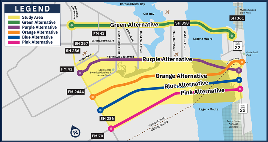
An environmental study is currently underway to explore potential route options for a proposed new crossing from the Corpus Christi mainland across the Laguna Madre to North Padre Island. The study limits are from SH 286 on the mainland to PR 22 on North Padre Island, a length of approximately 13 to 16 miles.
Two reasonable alternatives advance
TxDOT continues to evaluate and refine potential route alternatives. The updated map below highlights changes to the study area and two reasonable alternatives under consideration for the project. To learn more, please read our latest newsletter:
Alternatives moving forward
The Green and Orange Alternatives, shown on the map to the right, will continue to be evaluated and refined.
Alternatives removed
The Purple Alternative along Yorktown Boulevard has been removed due to community input and design challenges.
The Blue and Pink Alternatives were removed due to potential impacts to the historic King Ranch.
Public involvement is a critical component of TxDOT’s project development process. TxDOT encourages public input. Learn more about public engagement opportunities by visiting the Project updates page.
MEMORANDUM OF UNDERSTANDING: The environmental review, consultation, and other actions required by applicable Federal environmental laws for this project are being, or have been, carried-out by TxDOT pursuant to 23 U.S.C. 327 and a Memorandum of Understanding dated July 17, 2025, and executed by FHWA and TxDOT.