2.2 Long-Range Planning
Districts and Divisions use three types of long-range planning studies to identify transportation needs while determining critical elements of engineering and the economic feasibility of a proposed facility/route/corridor. Such studies establish design concepts, general ROW requirements and associated project impacts. Various elements associated with a study can include studying various alternatives, analyzing current and future traffic, analyzing potential environmental problems, development of cost estimates and determining feasibility.
The three types of studies discussed in this section include:
- Feasibility studies
- Corridor studies; and
- Route studies.
2.2.1 Feasibility Studies
Feasibility studies use technical data to assess the practicality of proposed improvements. A feasibility study aims to provide an independent assessment that examines all aspects of a proposed project, including technical, economic, financial, legal, and environmental considerations. This information then helps decision-makers determine whether to proceed with the project.
The study may show that the project is not economically justifiable - or that it creates so many environmental impacts that it is not viable. Early determination of such a finding will avoid unnecessary expenditure of funds on preliminary engineering and related costs.
A feasibility study may include studying multiple transportation corridors or routes within a corridor.
A feasibility study may be done at the District’s discretion or initiated by TPP. A feasibility study may be warranted in the following situations:
- Project is outside an MPO planning boundary;
- Project may involve a significant fund investment;
- Solution to the project is unknown;
- The project has significant environmental concerns;
- Consensus of general public and property owners along the route has not been developed;
- Unplanned traffic generator/development is anticipated;
- The need to prioritize project for funding;
- As directed by the Texas Transportation Commission (TTC); or
- As mandated by legislation.
Feasibility study requests are submitted through TxC. TPP - Corridor Planning Branch reviews and renders a decision on the request.
Feasibility studies analyze project specific features based on a variety of factors including transportation, environmental, socioeconomic, infrastructure, government and local agency coordination, and public involvement. These studies typically include a longer-term implementation horizon and a financial decision to proceed with project development.
The usual steps of performing a feasibility study are summarized as follows:
- Examine potential environmental constraints;
- Analyze present and future traffic;
- Study alternatives;
- Prepare preliminary plan drawing;
- Develop planning level cost estimate; and
- Conduct public involvement for study, if desired.
Feasibility studies can be programmed within the 10-year Unified Transportation Program (UTP) with the estimated let date as the anticipated year the study will be completed.
Feasibility studies are not construction projects
. TPP’s role is to review the feasibility study’s scope for statewide consistency. TPP Corridor Planning consultant contracts capacity may be used for feasibility studies if needed. TPP’s Corridor Planning Guidebook
provides additional information on feasibility studies.2.2.1.1 Planning and Environment Linkage Studies
A Planning and Environment Linkage (PEL) study is a high-level, early-planning study process that represents an approach to transportation decision making that considers environmental, community and economic goals early in the planning stage and carries them through project development, design and construction. The goal of PEL studies is to gather feedback during planning to inform the environmental review process, including the National Environmental Policy Act (NEPA) (see
).
Conducting a PEL study helps inform planning decisions and streamlines the project delivery process and can serve as a way for the public to discuss and prioritize transportation issues and project delivery. A PEL is most useful in the following situations:
- The project is identified as high rigor and complex (e.g., project is regionally significant, has environmental constraints, incorporates analysis of housing and community development options, is costly or controversial, or has the potential for many alternatives that could be indistinct and confusing).
- The project is not clearly defined during planning. PEL can help establish the scope of the project, purpose and need, or inform the likely level of environmental analysis that may be required.
- The environmental setting – whether there are natural features, critical habitat, built environment, disadvantaged communities, or population, employment, and land development projects – is not well known.
- Multiple alternatives need to be screened and eliminated during planning.
- Resources and regulatory agencies need to be engaged during the planning process to avoid and/or minimize environmental effects. This may include development of advance mitigation agreements or programmatic mitigation plans, creation of mitigation banks or preparation for permits or approvals.
2.2.2 Corridor Studies
The purpose of a corridor study is to assess existing and forecasted conditions along the highway corridor and develop a plan to implement various projects along the corridor, which are prioritized and phased based on need. Corridor studies are typically conducted along an elongated area that may span multiple counties, cities/towns, TxDOT Districts, and/or neighboring states (see
for an example corridor study map).
The study should include short (0-4 years), middle (5-10 years) and long term (10+ years) recommendations. From the implementation plan, the District(s) can then begin the process of planning and programming these projects into their respective project portfolios for further study and funding. However, there is no guarantee that any of the potential projects identified would be funded or implemented in the timeframes recommended in the corridor study.
Corridor planning is an early opportunity to establish a framework for integrating specific thoroughfare projects into the overall objectives for a local area and to bring public and private stakeholders together to discuss the transportation project(s). This helps to expedite the project development process by identifying and addressing key issues, opportunities, and community objectives before the design and engineering process begins.
The corridor planning process should have the following outcomes:
- Determine the relationships and needs for both mobility and land use along the corridor and in the subareas;
- Allow non-MPO communities to discuss multimodal transportation issues that may benefit their residents;
- Determine how decisions for individual thoroughfare segments affect the corridor and the transportation network as a whole;
- Establish objectives, operational concepts, context-based functions, performance measures and thresholds, land uses, access control and functional classification potential changes for an entire network or corridor, which can be applied to individual thoroughfare segments in project development;
- Allow for policy, social and public discussion of debate on issues that impact a broader area than an individual thoroughfare segment; and
- Identify additional related studies that may provide information for planning a project and assessing the relationship between a specific transportation project and neighboring community projects. Types of related studies include feasibility study, route study, toll road study, market study and value capture study. Obtaining and reviewing these studies can give a broader perspective of network and corridor needs.
Corridor studies can be initiated by Districts or TPP.
Urban and rural corridors have unique design characteristics. For planning purposes, rural corridors are outside urbanized areas and may be basic, developed, or suburban. Rural corridors may be defined by scenic purpose, connection between urban areas or by accommodating surface freight transport. Refer to the Statewide Planning Map referenced below for information on corridor context classification and functional classification.
Refer to TxDOT’s
Transportation Planning and Programming Manual
for additional discussion on corridor studies.The Statewide Planning Map displays data in support of planning operations at TxDOT. Base map options include TxDOT, Texas Imagery Service, TxDOT Light Gray, TxDOT Dark Gray, Esri Streets, Open Street Map. Overlay options are indicated as table of contents.
2.2.2.1 Resiliency Planning
As a part of corridor planning and strategic projects, planning for public security must be considered. TxDOT initiated the Statewide Resiliency Plan (SRP) to strengthen the resilience of the State’s multimodal transportation system to a range of potential hazards.
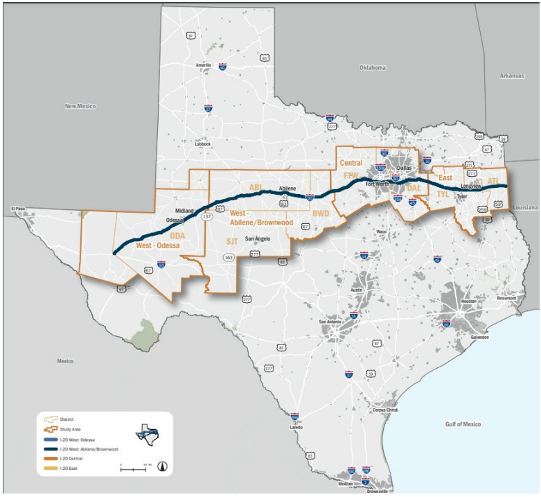
Figure 2-3: Example I-20 Corridor Planning Map
Every year, the State’s transportation system is at risk to extreme weather events, such as riverine and coastal flooding, extreme heat, extreme cold, Intelligent Transportation System (ITS) security threats and other human-made hazards such as dam and levee failures. These hazards can damage transportation infrastructure and disrupt operations, with cascading impacts for public safety and health, freight and supply chains and the Texas economy. Texas is also a significant national and international supplier of energy products with refineries and distribution infrastructure near the Texas transportation network.
Findings and recommendations of the SRP serve as a resource to TxDOT Divisions and Districts for incorporating transportation resilience into statewide, regional and local transportation planning and project development. A science-based approach, informed by stakeholder input, generates strategies and solutions that can anticipate current and future hazards for decades to come.
2.2.3 Route Studies
Route studies are typically conducted to evaluate two or more geometric alternatives associated with a specific project location. The purpose of a route study is to identify a specific build option(s) for further detailed schematic design and/or environmental impact analysis.
Many times a route study is associated with some type of “relief route” around cities/towns that is forecasted to experience adverse traffic congestion, has outdated roadway design criteria or has other circumstances where a route study is desired.
illustrates an example of a route study map.
Route options typically include the construction of roadways on new alignment or along the existing highway where substantial improvements would:
- Increase capacity, such as new main lanes and/or frontage roads;
- Enhance mobility, such as limiting access and grade separations such as overpasses and interchanges; and
- Improve safety.
Route options can include moving traffic around new developments or design elements to accommodate bicyclists, pedestrians, public transportation and railroads.
Route studies do not include high-occupancy vehicle (HOV) lanes, toll lanes, tolled facilities or managed lanes as route options.
Refer to TxDOT’s
Transportation Planning and Programming Manual
for additional discussion on route studies.TxDOT’s Open Data Portal is the agency’s platform for exploring and downloading GIS datasets. The portal allows users to view datasets on a map, filter data using queries, and download data in various formats.
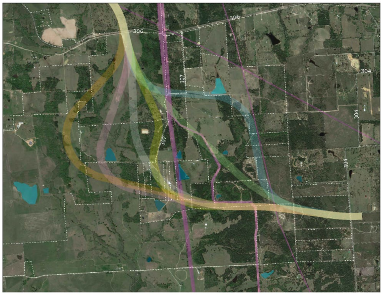
Figure 2-4: Example Route Study Map
|
|
|
|
|