Chapter 9 Segment Analysis (Freeways, Multi-Lane Highways, TwoLane Highways, Arterials, and Frontage Roads)
9.1 Introduction
9.1.1 Overview
This chapter covers the following types of segment analysis: basic freeway segments, basic multi-lane highways, weaving segments, merge and diverge segments, two-lane highways, arterial segments, and frontage roads. Definitions of the various facility types are provided later in this section. Three levels of detail are used to describe tools recommended for segment analysis:
- Sketch-level or macroscopic tools are typically used for projects in the Planning stage or for projects with a large geographic scope. These tools include:
- TDM
- Service volume tables
- HCM-based (mesoscopic) tools are typically used for projects in the Preliminary Schematics stage or for projects that need moderate levels of detail. These tools include:
- HCS, FREEVAL, and HCM-CALC
- Microsimulation (microscopic) tools consider individual vehicles and their movements and are typically used for projects in the Final/Approved Schematics and Design stage. These tools include:
- Vissim and CORSIM
The tools available to perform each type of analysis are shown in based on segment type and level of detail.
9.1.2 Facility Definitions
9.1.2.1 Freeways
A freeway has two or more lanes in each direction access-controlled via ramps. Freeway facilities are typically broken up by “sections” or “segments.” Sections of a freeway are defined as the areas between two ramp gore points. The HCM defines several segment types, including basic, weaving, merge, and diverge segments. See for an illustration of a merge, diverge, and weaving segment. Freeway facilities are typically composed of more segments than sections. Analyzing freeway facilities by sections, by segments, and in its entirety are covered in this chapter.
Segment Type | Sketch-level or macroscopic | HCM-based (mesoscopic) | Microsimulation (microscopic) |
|---|---|---|---|
Freeways (Basic)1 | Travel Demand Model output, Service volume tables | HCS, Freeval, HCM-CALC | Vissim, CORSIM |
Multi-lane Highways (Basic)2 | Travel Demand Model output, Service volume tables | HCS, Freeval, HCM-CALC | Vissim, CORSIM |
Weaving3 | Travel Demand Model output | HCS, Freeval, HCM-CALC | Vissim, CORSIM |
Merge and Diverge4 | Travel Demand Model output | HCM method, HCS, Freeval, HCM-CALC | Vissim, CORSIM |
Two-lane Highways | Travel Demand Model output, Service volume tables | HCS, Freeval, HCM-CALC | Vissim, CORSIM |
Arterial Facilities | Travel Demand Model output, Service volume tables | Synchro, HCS, Freeval, HCM-CALC | Vissim |
Frontage Roads | Synchro or other HCMbased tool | TTI Procedures5 | Vissim |
1
A segment of freeway outside the influence area of any merge (1,500 feet), diverge (1,500 feet), weaving segments (500 feet), or any signalized intersections (2 miles). 2
A segment of highway outside the influence area of any merge (1,500 feet), diverge (1,500 feet), weaving segments (500 feet), or any signalized intersections (2 miles). 3
The crossing of two or more traffic streams traveling in the same direction along a significant length of highway without the aid of traffic control devices. Often formed when merge segments are followed by diverge segments. 4
Primarily occurs at on-ramp and off-ramp junctions with a freeway mainlane. 5
TTI procedures are deterministic but are not HCM-based (mesoscopic). These procedures are discussed in section 3 of this chapter.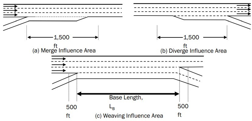
Figure 9-1: Illustration of Merge, Diverge, and Weaving Segments from the HCS7 User Guide (Segment Length subsection)
9.1.2.2 Highways
Two types of highways are covered in this chapter: multi-lane (two or more lanes in each direction) and two-lane highways (one lane in each direction). Multi-lane highway segments are analyzed similarly to basic freeway segments. In some instances, multi-lane highways are like freeway segments or arterials, based on the access density and speed.
For two-lane highways, vehicles pass using the opposing lane of traffic. Two-lane highways can include intercity connectors, regional connectors, intracity connectors and may pass through scenic areas or areas with challenging terrain.
9.1.2.3 Arterials
Arterial/urban street segments are bounded by intersections or ramp terminals where the through-movement for the segment is signalized, stop-controlled, or yield-controlled. If these boundary intersection control types do not exist, the segment can be bounded by a two-way stop controlled (TWSC) intersection with stop control on the cross street. Arterial facilities made up of multiple arterial segments can also be analyzed.
9.1.2.4 Frontage Roads
Frontage roads, or service roads, run parallel to a controlled-access facility, serving as connectors between ramps of the higher-speed facility and intersections of lower-speed local streets. Their primary purpose is to provide access to local properties and allow the mainlane users to bypass intersections and driveways. They can either have one-way or two-way operation. Frontage road segments are typically bound by ramps, signalized intersections, or intersections with stop or yield control.
9.1.3 Purpose and Intended Use
The purpose of this chapter is to provide an overview of the tools, data requirements, input parameters, and MOEs for three levels of segment analysis: Sketch-level or macroscopic, HCM-based (mesoscopic), and Microsimulation (microscopic). Each tool corresponds to a different level of precision and accuracy. This chapter is intended to be used as a resource and informational guide for practitioners and covers the latest methodologies, practices, and procedures for analyzing segments. This chapter generally follows the HCM but also recommends different tools and methodologies where limitations exist.
9.1.4 Limitations
As of 2024, there is only one published methodology to analyze frontage road operations. This chapter does not address freeway work zones, managed, or toll lanes. More information can be found in HCM 7th Edition, Chapter 10.
This chapter does not cover freeway to urban street interactions. For information on urban street interactions, refer to NCHRP 15-57 HCM Methodologies for Corridors Involving Freeways and Surface Streets (2020). It has information on evaluating operations and impact of spillback on networks that include both freeways and urban streets. This method evaluates freeway performance by lane, as spillback affects each lane of the freeway differently. The resulting trip-based performance measurement framework provides travel time estimates for given OD pairs within a highway network. Safety aspects of segment operations are also not covered in this chapter. See
Chapter 5
and Chapter 6
of this manual for segment safety analysis information.