3.3 Context Classification System
The context classification system broadly identifies various environments in Texas as illustrated in
. This figure should not be taken as a literal depiction implying all roadways will have every context classification or that context classifications occur in the sequence shown. However, it is good practice that a freeway connects to an arterial, an arterial connects to a collector and a collector connects to a local street.
Identifying the context classification of a roadway is a required step
in the planning phase of the project development process. It is essential to identify the appropriate design criteria in relation to the functional class and the intended use of the roadway. The project development process is further discussed in the
.Context classification is a supplemental means to identify the anticipated users of the roadway and the needs of those users. It is important to understand the user type and needs early in the project life cycle. The context classification for a roadway is determined during project scoping and is documented in the DSR.
Understanding the needs of all users in the early phases of a project assures that the project scope of services defines all necessary improvements. The project context classification should be determined and/or reevaluated at the beginning of each phase of project development including planning, preliminary engineering, and final design.
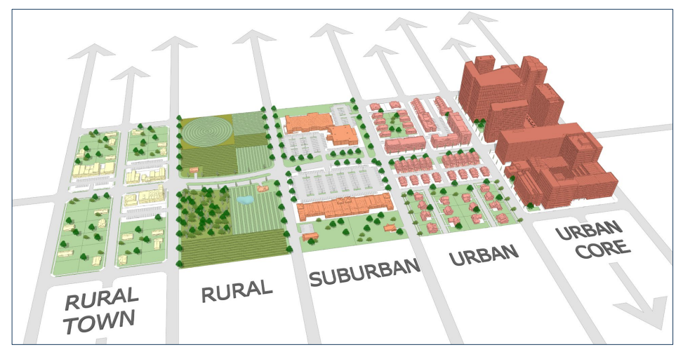
Figure 3-3: TxDOT Context Classifications
3.3.1 Determining Context: Factors and Process
The general framework for the demarcation between various contexts is shown in
.
describes the primary characteristics of the respective context:
- Development density (existence of structures and structure types);
- Land uses (primarily residential, commercial, industrial, and/or agricultural);
- Building setbacks (distance of structures to adjacent roadways);
- Sidewalk and parking accommodations;
- Transit and freight accommodations; and
- Intersection/driveway density.
The context classification process does not rely solely on quantitative data or analysis (e.g., persons per square mile or building square footage), but can be used where broad comparative development differences are encountered. The context classification and functional class decisions become the starting point for geometric design choices because these choices address the modes to be accommodated and their interactions. The context category should be assigned based upon generally observed conditions within and among the determining factors as well as the consideration of expected future changes in land use patterns. The roadway planning and design process should take into account anticipated future context conditions that are often defined through State, regional, and local planning documents.
Functional class drives the function of the roadway, context classification drives the constraints of the roadway.
An Urban area, as defined by FHWA, has a population of 5,000 or greater (based on the latest Census data); all areas below a population of 5,000 are currently classified as rural. These areas can be seen on the
that is maintained by TPP . Per FHWA guidance, after each decennial census, TPP, in partnership with the MPOs and Districts, expand the urban areas for transportation planning purposes. This is generally completed about 3 years after the latest decennial census
In a recent effort, TPP (in collaboration with TTI) has developed layers in the
that will visually show context in a baseline year, 10-year forecast, and 20 year horizon down to the Traffic Analysis Zone (TAZ) level. These layers are based on the travel demand models trip generation forecasts for the respective MPO area. These layers will provide designers with an additional tool to help distinguish between urban core, urban, suburban, and rural contexts; the layers also have a finer degree of gradation for areas that are on the cusp between Urban Core and Urban, as well as between Suburban and Rural. This tool is located on the
under the layer (TPP_TDM_AreaType). Contact TP&P (GIS Management Section) for access credentials.
Note that a rural town does not have a specific quantitative definition and thus may reside in either an urbanized or rural area.
The subsequent sections in this chapter further describe and depict urban core, urban, suburban, rural town, and rural contexts. Note that urban core, urban, suburban, and rural town are considered “urbanized” contexts.
Context Classification | Development Density | Land Use | Setbacks | Sidewalk and Parking | Transit and Freight | Intersection / Driveway Density |
Rural | Lowest (few houses or other structures) | Agricultural, natural resource preservation, and outdoor recreation uses with some isolated residential and commercial | Usually large setbacks | No sidewalks or on-street parking | Little transit; moderate freight | 1-10/mile |
Rural Town | Low to medium (single-family houses and other single purpose structures) | Primarily commercial uses along a main street with some adjacent single-family residential | Predominately small setbacks | Some on-street parking and some sidewalks | Little transit; moderate freight | >30/mile |
Suburban | Low to medium (single- and multifamily structures and multistory commercial) | Mixed residential neighborhood and commercial clusters (includes town centers, commercial corridors, big box commercial and light industrial) | Predominately large setbacks | Some sidewalks and no street parking | Little transit; moderate freight | 10-30/mile |
Urban | High (multistory, low-rise structures with designated off-street parking) | Mixed residential and commercial uses, with some institutional, industrial, and prominent destinations | Mixed setbacks | On-street parking and sidewalks | High transit; moderate freight | >30/mile |
Urban Core | Highest (multistory and high-rise structures) | Mixed commercial, residential, and institutional uses within and among predominately high-rise structures | Small setbacks | On-street parking and sidewalks and pedestrian plazas | High transit; low freight | >30/mile |
3.3.2 Rural Context
The level of development in rural contexts ranges from minimal (no development) to light (a few structures). Most land is used for outdoor recreation, agriculture, farms, and resource extraction. Unincorporated areas may include a few residential and commercial structures. Building setbacks are typically large but can taper near intersections and crossroads where development is present. Population densities are low. Speed expectations for drivers are higher, with infrequent driveways or intersecting roads and few slowing or turning vehicles. Examples of typical rural areas are shown below.
Typical characteristics are:
- Few houses or structures;
- Widely dispersed residential, commercial, or industrial land uses;
- Long-distance bicyclists using highway shoulders:
- Large building setbacks; and
- Undeveloped land, farms, large outdoor recreation areas, or low densities of other types of development.
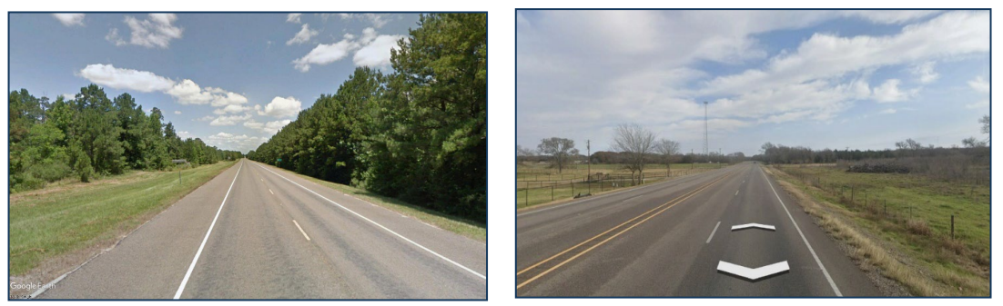
Figure 3-4: Example Roadways in Rural Context
Source: Google Maps
3.3.3 Rural Town Context
A rural town does not have a specific population definition and thus may reside in either an urbanized or rural area as currently defined in the
. Rural town contexts feature small concentrations of developed areas, including historic towns, surrounded by rural areas, undeveloped areas, and natural areas. Building densities are lower, but often resemble urban development patterns and consist of low-rise structures (one or two stories). Most land use is residential or commercial. Relatively compact residential uses are expected, and schools may be present. Building setbacks are small and much narrower than surrounding areas. A basic street network is usually in place. Rural highways change character where they enter a rural town. Driver speed expectations are lower, with a higher likelihood of encountering slowed or turning vehicles, pedestrians, and bicyclists. Examples of typical rural town areas are shown below.
Typical characteristics are:
- Low development densities with mixed land uses;
- Some on-street parking;
- Average building setbacks less than 50 ft;
- Average driveway densities greater than 30 driveways/mile on both sides of the road;
- May include residential neighborhoods, schools, industrial facilities, and commercial main street business districts; and
- Some pedestrian and bicyclist activity, often with sidewalks and marked crosswalks in some locations.
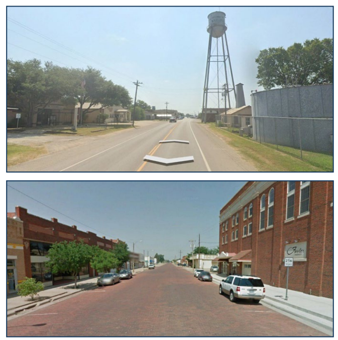
Figure 3-5: Example Roadway in Rural Town Context
Source: Google Maps
3.3.4 Suburban Context
Suburban contexts include an array of commercial and residential uses, low to medium densities, medium to large building setbacks (to accommodate off-street parking), and large block sizes. Suburban areas are usually connected to urban areas. Buildings tend to be single story or low-rise structures, with off-street parking in commercial areas. Residential areas are populated by mostly single-family (with some multifamily) housing and some neighborhood parks. Drivers have higher speed expectations than the urban contexts, but lower speed expectations than the rural contexts. Suburban areas are generally short sections, approximately 1 – 3 miles in length, and transition between rural and urban contexts. The suburban context may be more applicable in areas of anticipated future growth that eventually will become an urban context based on future land-use expectations within the expected design life of the facility. Examples of typical suburban areas are shown below.
Typical characteristics are:
- Low-to medium density development;
- Mixed land uses with single-family residences, some multi-family residential structures, and/or nonresidential development including mixed town centers, commercial corridors, big box commercial stores, light industrial development;
- Building setbacks are varied;
- Driveway densities between 10 - 30 driveways/mile on both sides of the road;
- Mostly off-street parking; and
- Pedestrians and bicyclist activity; may or may not have sidewalks and marked crosswalks.
The term “town centers” refers to areas within a town or city where commercial, social, and civic activities are concentrated. Town centers typically feature shops, restaurants, offices, and public spaces.
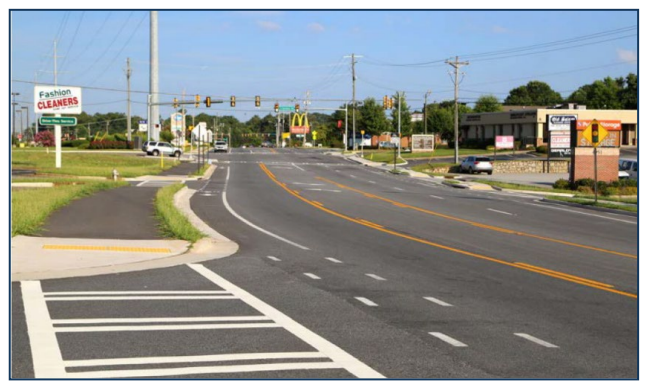
Figure 3-6: Example Roadway in Suburban Context
Source: Graham-Smith Partners – AASHTO Green Book 7th Edition
3.3.5 Urban Context
Urban contexts are medium to high density and consist mainly of multistory and low-to medium-rise structures for residential, commercial, and institutional use. Many structures are mixed use: commercial, residential, and parking. Building setbacks are typically small with pedestrian-focused building orientations. Urban contexts generally experience lower driver speed expectations, with a higher likelihood of encountering stopped or turning vehicles, pedestrians, and bicyclists. Examples of typical urban areas are shown below.
Typical characteristics are:
- High-density development;
- Some on-street parking;
- Varied building setbacks Multi-story and low-to medium-rise structures for residential, commercial, parking and educational uses;
- Light to heavy industrial land use;
- Prominent destinations with specialized structures, (e.g., large theaters, sports facilities, or conference centers);
- High levels of pedestrian and bicyclist activity, with nearly continuous sidewalks and marked crosswalks;
- Higher density of transit stops and routes;
- Driveway densities greater than 30 driveways/mile on both sides of the road;
- Minor commercial driveway densities of 10 driveways/mile or greater; and
- Major commercial driveways.
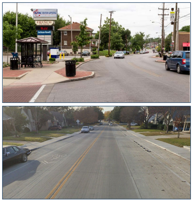
Figure 3-7: Example Roadway in Urban Context
Source: Graham-Smith Partners – AASHTO Green Book 7
th
Edition (Top Image)3.3.6 Urban Core Context
Urban core context houses the highest level of development density with its mixed residential and commercial uses accommodated in high-rise structures. While there may be some on-street parking, it is usually very limited and time restricted. The area is accessible to automobiles, commercial delivery vehicles, and public transit. Bicycle facilities and transit corridors are common. Structures may have multiple uses, and setbacks are not as generous as in the surrounding urban area. Examples of typical urban core areas are shown below.
Typical characteristics are:
- High-density development;
- On-street, time-restricted parking, or off-street in parking structures;
- Small building setbacks;
- Driveway densities greater than 30 driveways/mile on both sides of the road;
- High pedestrian, bicycle, and transit use; and
- Multi-story and high-rise structures for residential, commercial, and educational uses.
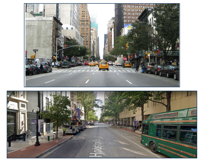
Figure 3-8: Example Roadway in Urban Core Context
Source: Graham-Smith Partners – AASHTO Green Book 7
th
Edition (Top Image); Google Maps (Bottom Image)