3.7 Stormwater Management
Per TxDOT’s
l (HDM), Chapter 13, Storm Water Management, “Storm water is defined in the Construction General Permit (CGP) as "Rainfall runoff, snow melt runoff, and surface runoff and drainage." For TxDOT purposes, storm water includes overland flow, and flow in ditches and storm drain systems.” Many of the large land areas encompassed by highway interchanges have been used for aesthetic as well as practical purposes. One primary purpose of these sites is stormwater management, employing green infrastructure techniques.
Within the aesthetic parameters of landscape architecture, designers can employ the following techniques to manage stormwater runoff through the landscape and reduce the damaging effects of erosion:
- Provide suitable vegetation buffers on slopes;
- Create flatter slopes in drainage ways, 3:1 max, with 6:1 preferred; and
- Reinforce turf lined drainage channels with geosynthetic fabrics to prevent scouring, especially at concentrated flow areas.
3.7.1 Green Infrastructure
The three types of facilities below provide differing levels of biofiltration, conveyance, and flood control. These should be designed in accordance with the
.
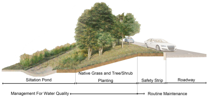
Figure 3-14: Basin Section
3.7.1.1 Ponds and Water Quality Structures
The following design parameters related to the development of PS&E for wetlands, detention ponds, and water quality structures are as follows:
- Water may be released through designed outfall or overflow structures.
- Structure is protected with curbs or other barrier devices where appropriate.
- Natural, freeform design is preferable.
- Detailed grading plan to establish shape and grades of the structures.
- Cross sections of weirs, dams, outlet structures, subdrainage, and spillways.
- Specifications for filter sands, soil additives, clay or fabric liners, and temporary erosion control.
- Setbacks and side slopes that allow for driver recovery of errant vehicles.
- Side slopes are designed for maintenance activities (mowing), see ;
- Appropriate vegetation for the pond use.
- Designed to provide flood control, remove silt and pollutants, and protect downstream water bodies.
- Rain gardens and biofiltration ponds should be designed so that water is held for no longer than 48-72 hours. Otherwise, the pond could develop nuisance conditions where mosquitos can breed.
3.7.1.2 Rain Gardens
- Typically used for smaller drainage areas (less than 1 acre). See .
- Biofiltration Ponds typically have drainage areas larger than one acre.
- Used for retention and/or infiltration, and typically less than 12” depth.
- With infiltration-type rain gardens, water flows in slowly and is not released, but instead percolates into the groundwater through porous soils.
- In locations with native clay soil, the water quality facility must incorporate an underdrain.
- Vegetation may be comprised of turf and/or other plant material but is always specifically selected for periodic inundation.
- Appropriate substrate for the region is utilized for the rain garden base.
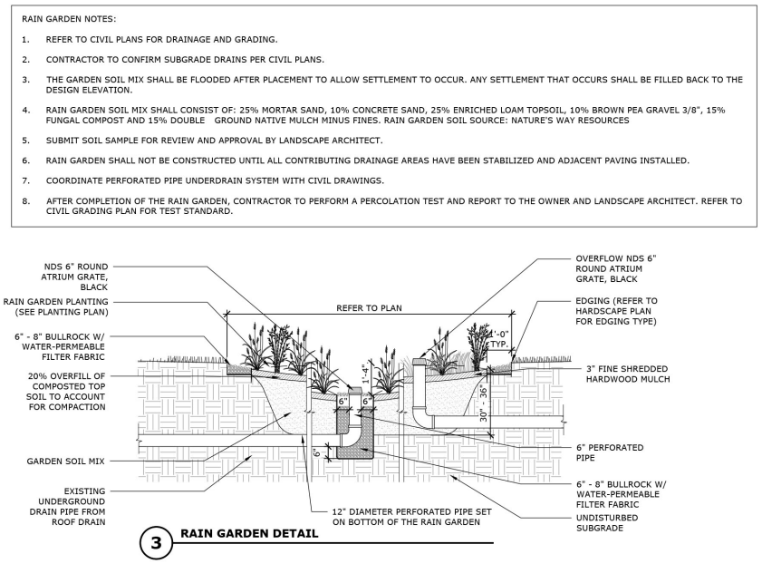
Figure 3-15: Rain Garden
3.7.1.3 Vegetated Drainage Swales/Channels
- Used as conveyance, with vegetation filtering and slowing runoff.
- Aligned to drain to a specific location.
- Vegetation suitable for variable flow rates, as well as periodic inundation.
- Side slopes designed for periodic maintenance.
- Utilize an approved channel lining material.
3.7.2 Wetlands
“Wetlands are areas where water covers the soil or is present either at or near the surface of the soil all year or for varying periods of time during the year, including during the year.” (US EPA Website definition for sources list) For information on wetlands located in TxDOT ROW refer to the Water Resources section of TxDOT’s Environmental Affairs Division’s (ENV)
. Occasionally, TxDOT may be required to design and construct wetlands as part of environmental mitigation.
Areas immediately along the roadway have frequently been altered from their original grade and yet may still qualify as wetlands. Per the U.S. Corps of Engineers, wetlands are "those areas that are inundated or saturated by surface or ground water at a frequency and duration sufficient to support, and that under normal circumstances do support, a prevalence of vegetation typically adapted for life in saturated soil conditions." (Refer to TxDOT’s
, Section 5: Wetlands/Streambed Permits, and the location’s District or Division environmental staff before proposing any design in these areas).
Refer to the ENV Division’s
for mitigation requirements.