2.2.5 Speed, Travel Time, and OriginDestination (OD) Data
Speed is a fundamental MOE for traffic operational analysis. Speed is measured in two ways: time-mean-speed (TMS) and spacemean-speed (SMS). TMS is calculated by recording the speeds of individual vehicles passing a point over a selected period of time. SMS is calculated by dividing the average travel time by the distance of that route. This is an important distinction, as some methods of collections use TMS, while others use SMS; this difference can lead to different speeds for the area of interest, if not carefully distinguished. TMS is typically used when the speed at a point is of most interest, and the SMS is used when the speed over a section of roadway is of most interest. SMS is also used when analyzing and reducing travel time data.
Travel time is the time to traverse a route from point A to point B and is a fundamental MOE for traffic engineering.
OD data is also another important traffic characteristic that may be helpful in determining travel patterns. OD datasets provide information on trips between userdefined geographic zones or roadways. These datasets may also have additional information related to the mode of transportation, such as organizing data by pedestrians, bicyclists, and freight.
Additional information about Probe-Based Data, Bluetooth Sensors Data, and Floating Cars Data is shown in this section. This additional information provides guidance on the different methods of collections for speed, travel time, and OD data.
2.2.5.1 Probe-Based Data
Probe-based data is collected from individual vehicles, or probes, over space and time, rather than collected at a specific place and time. The most common types of probe-based data collection methods are Automatic Vehicle Location (AVL), Global Positioning System (GPS) mobile devices, and third-party cell phone app data. This data is typically collected by thirdparty companies that parse through the data, anonymize it, and convert individual probe data into performance measures such as speed, travel time, and OD. This data is then used for traffic analysis. The data can also be used to determine OD of trips and queuing.
Floating car data (FCD) is a type of probebased, timestamped, geospatial data that provides speeds and travel times. The data is collected by using an application or a GPS device that records timestamps and geospatial data while the application or device is driven through the area of interest. The driver attempts to “float” in the traffic stream, selecting a location in the traffic flow where the vehicle’s speed matches that of the surrounding vehicles to allow the probe to collect data of a typical vehicle along the facility during the analysis period. FCD is recommended to be collected on typical weekdays (Tuesday, Wednesday, Thursday) and during the peak period. A minimum of five runs in each direction per peak period are typically performed for a more representative view of existing traffic conditions, as demonstrated by . FCD provides a sample of the existing congestion, speeds, stops, and travel times for the study area during a peak period.
TxDOT has access to probe-based data, such as INRIX, which can be used for traffic analysis. See
Section 2.3 Existing Traffic Operations Data Sources
in this chapter for more information.2.2.5.2 Bluetooth Sensors Data
Bluetooth sensor data is like probe-based data but is more localized and needs specialized hardware. Most vehicles manufactured today are equipped with Bluetooth devices, as are personal electronics such as phones, laptops, and tablets. Bluetooth sensors used for traffic engineering scan for other Bluetooth-enabled devices near the Bluetooth sensor device. Once a device is read by the Bluetooth sensors, it stores data related to the detected device. This data can be used to conduct OD studies, determine vehicular density, and conduct flow analysis. When using Bluetooth sensors for traffic engineering, the placement of these sensors is key. Placing these sensors under overpasses, or where multiple roadways are crossing over or under each other, may create challenges, such as not being able to identify the overpass or roadway on which the device was read. This can also occur at intersecting roadways with many pedestrians with cellphones. Post-processing of this data to minimize such issues is suggested. This method only gathers information for vehicles with Bluetooth devices present in the vehicle.
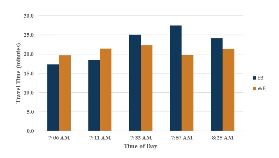
Figure 2-2: Floating Car Travel Time Runs