2.2 Landscape and Aesthetics Assessment
The objectives of the LAA are to identify opportunities and constraints within the corridor, especially as they pertain to the following:
- Recognizing landscape and aesthetic issues that will impact the character, cost, and/or sustainability of a transportation project;
- Ensuring that the landscape and aesthetic qualities of a corridor have been considered as required by law;
- Distinguishing items related to the character of architectural features and details;
- Categorizing elements that relate to the selection of materials, colors, and color schemes;
- Ascertaining regionally appropriate design themes;
- Informing entities about the opportunities for cost sharing; and
- Gathering information that will assist in estimating development costs.
2.2.1 LAA Development Process
Step Number | Tasks |
Step 1 | Identify the highway corridor segment |
Step 2 | Inventory the corridor |
Step 3 | Identify opportunities and constraints |
Step 4 | Assess the sensitivity of the corridor to construction and change |
Step 5 | Develop a landscape and aesthetics assessment statement |
Step 1: Identify the Highway Corridor Segment
A highway or transportation corridor does not usually correspond to the exact physical limits of a project. To ensure visual and aesthetic continuity, it is important to fit project-related aesthetic design decisions into a recognized corridor segment. A corridor is a section of highway possessing significant tangible boundaries. Characteristics that usually impact the perception of boundaries are physical features, significant intersections or bridge crossings, historic districts, or neighborhoods, commercial or institutional centers, or distinctive scenery or open space.
The key to corridor definition is identifying beginning and ending points that are meaningful to local residents
. See
.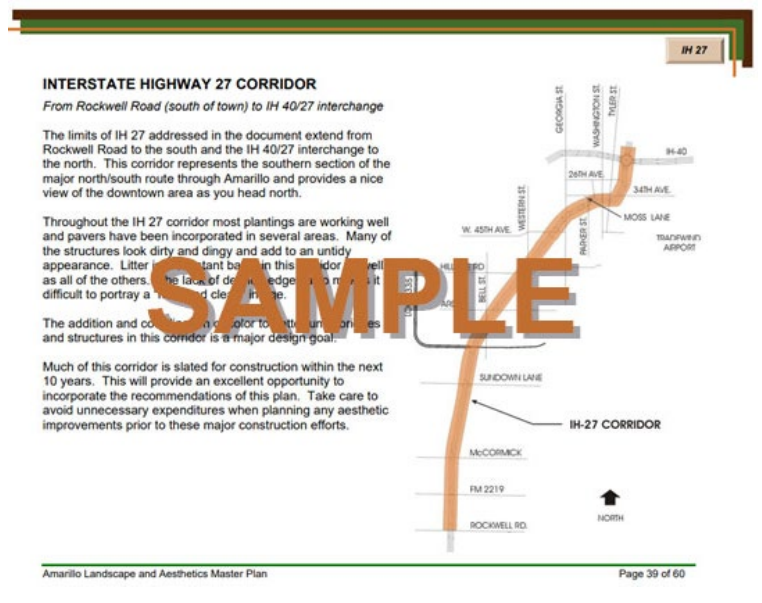
Figure 2-1: Example of Corridor Segment (SAMPLE)
Step 2: Inventory the Corridor
The LAA inventory involves collecting data and documenting a variety of existing physical and contextual surroundings, while anticipating the proposed corridor impact.
Corridor Geometry - Physical surroundings
Be aware of the potential for significant change created by proposed geometry or alignment; drastic character changes can cause adverse public reactions. Rural and urban landforms are impacted differently by highway corridors. For example, in most urban areas, projects to expand the number of lanes within an existing ROW will require the use of numerous retaining walls and/or sound walls which will change the views, character, and feel of the existing highway.
In a rural, natural landscape with high topographic relief, the cuts and fills of proposed corridor development result in sharp visual contrast with the natural forms of the topography as shown in
.

Figure 2-2: Topography/Rural Landforms
In urban areas, the highway corridors can become concrete canyons or tunnels in the urban skyline as shown in
. It is important that the potential impact be recognized and that any potential adverse public reaction to this impact be recognized early in the process. (See also discussion on topography and grading in
)
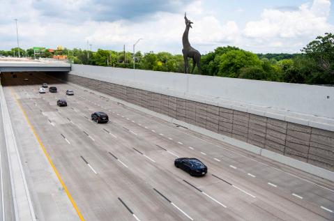
Figure 2-3: Attention to textures and colors in deep cuts can keep areas from being a negative driving experience.
Corridor Geometry - Contextual surroundings
Where the public is concerned, the neighborhood context is the most important part of the landscape and aesthetics assessment. Residents, businesses, and institutions that border a transportation corridor have a vested interest in the overall design. Studying the neighborhood context and identifying public concerns are vital to the success of the project. This requires participation in the public engagement process and careful attention to comments that relate to landscape and aesthetics design.
The cultural properties of a corridor relate to the historical and regulatory framework that may overlay a project. Ephemeral properties (i.e., the characteristics of a site that change with time, such as the progression of seasons or play of light and shadow) apply to a LAA. Designers must be aware of these influences, since they are often difficult, or impossible to see, yet evoke very strong emotional ties within a community. Elements such as a local reverence for a seemingly insignificant church building or the seasonal bloom of regionally prized trees can cause significant delays in a project if the value to the community is not recognized early in the design process.
Step 3: Identify Opportunities and Constraints
Based on the material gathered in the inventory, identify the corridor’s visual and aesthetic opportunities and constraints. The objective of this step in the assessment is to be broad. Consider all the possibilities and reduce the focus on details.
Opportunities
The goal in the LAA is to identify anything that could be considered an opportunity or an asset to the design process, no matter how it might be used in a final design recommendation. Opportunities are any physical or contextual characteristics that would allow enhancement of the visual, scenic, and environmental qualities of the highway corridor as shown in
. This may be related to alignment, landform, adjacent property conditions, or vegetation as well as the ephemeral properties of a community. The availability of ROW also provides very important opportunities that should not be overlooked.
Communities that have an interest in partnering with TxDOT for landscape and aesthetics improvements, exhibited by a willingness to assume responsibility for long-term maintenance, should be actively recruited.
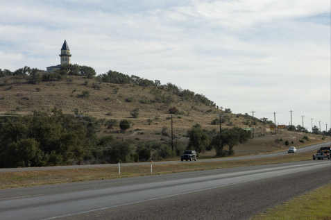
Figure 2-4: Landmarks as Orientation Elements
Constraints
Constraints may include physical landscape limitations as well as potential conflicts with adjacent property owners or communities that will make project design difficult. Significant physical conflicts are usually obvious.
Much less obvious are the conflicts that arise because of public perceptions of a project or conflicts that arise out of the cultural context of place. These are most often related to the history of a place or local customs and traditions.
Step 4: Assess the Sensitivity of the Corridor to Construction and Change
The sensitivity of a corridor to development and change must be judged based on the opportunities and constraints identified. It is difficult to suggest any specific guidelines or tools that would be helpful in making this judgement. However, if each area of the inventory is addressed and reviewed in terms of the opportunities and constraints, the relative sensitivity to the corridor development will generally be evident. Examples of land uses that tend to have high sensitivity to development are:
- Established residential neighborhoods;
- Historic areas/districts;
- Regional parks, including areas of botanical interest and special habitats;
- Special districts, medical facilities, retail centers;
- Areas of high scenic quality, mountain, ocean or water views, panoramas, etc.;
- Wetlands and aquifer recharge zones;
- Developed urban freeway corridors;
- Churches/burial sites; and
- Stormwater management and green infrastructure.
When any of these types of land uses are encountered, special attention should be given to the documentation process, as well as the public engagement process. These are the primary initial opportunities to identify the critical issues within the corridor boundaries. The information assembled and documented during this step informs the detailed design process, which in turn should ensure that the proposed project does not negatively impact the surrounding areas as shown in
. Collaboration and coordination with TxDOT environmental staff are often required during this step.
Figure 2-5: Example of Project Documentation
Step 5: Develop an LAA Statement
The purpose of the LAA Statement is to document the aesthetic issues that need to be addressed in the detailed design process. The statement should frame issues in a way that encourages a positive design response. For example, if a new corridor alignment endangers a stand of prized trees in a neighborhood, the assessment should identify the tree species and location and indicate what actions may be necessary to protect and save the trees. Or, if the corridor alignment cannot occur without damaging the trees, what measures would be appropriate, such as relocation/mitigation. Similarly, where neighborhood concerns such as objectionable views are evident, the assessment should state the issue and present design options that could be cost effective in mitigating the problem. The goal of the LAA Statement is to identify the issues and provide suggestions that maximize design flexibility.
2.2.2 LAA Statement Outline
The following elements should be included in the LAA Statement outline:
Project Scope
- Physical location and description of work (e.g., Widening of IH-45 from 610 south to IH 69)
Inventory of Corridor
- Identification of corridor (indicate whether corridor design runs beyond physical project construction limits);
- Inventory of physical properties;
- Physical surroundings; and
- Contextual surrounding issues arising from public engagement process.
Design Considerations
- Discuss specific landscape and aesthetics design issues that should be addressed in the detailed design process;
- Present options rather than individual or specific design solutions; and
- Couch the proposed project statement in terms that relate to the language of public engagement.