I-30 East Texas Corridor Study
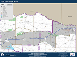
Interstate 30 provides an important east-west connection for travel and trade. As the Interstate System ages, and population and trade increase in Texas, it is necessary to assess the current safety and capacity needs and plan for the future. This corridor study identified transportation needs in northeast Texas along I-30 from Farm-to-Market Road (FM) 2642 near the Rockwall/Hunt county line to the Texas/Arkansas state line in Texarkana. It is approximately 145 miles in length, crossing six counties, and located within the TxDOT Paris and Atlanta Districts. The Executive Summary and the full Final Report are provided below.
I-30 Corridor study working group
To best understand community needs and concerns, local communities and leaders were engaged in the study. Similar to previous TxDOT studies, an I-30 Working Group was established. The Working Group helped TxDOT identify and assess the transportation needs in the corridor, inform and gather input from the public, and recommend priorities and next steps for TxDOT and other local entities.
This I-30 Working Group comprised 21 elected officials and other stakeholders along the I-30 corridor and includes representatives from:
- Bowie County
- Dallas County
- Hunt County
- Morris County
- Rockwall County
- Titus County
- City of Greenville
- City of Mount Pleasant
- City of Mount Vernon
- City of Sulphur Springs
- City of Texarkana
- Texarkana Metropolitan Planning Organization
- Franklin County
- Hopkins County
- Arkansas/Texas Council of Governments
- North Central Texas Council of Governments
- North East Texas Regional Mobility Authority
- Sulphur River Regional Mobility Authority
- Luminant Mining
- Red River Army Depot
- TexAmericas Center