4.5 Air-coupled Ground Penetrating Radar (GPR)
This van-mounted self-contained system carries a data acquisition boom-mounted antenna off the front of the vehicle, suspended above the roadway. This allows for uninterrupted data collection at near-highway speeds. The system sends pulses of radar energy into the pavement and captures returned reflections from each perceived layer interface within the structure. A survey is generally run in the right wheel path with data summarized at 10-ft. intervals; the effective width of the scanning is about 8.0 in. If data is needed at other transverse locations along the lane, additional parallel passes must be made.
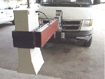
Figure 4-8. Air-coupled Ground Penetrating Radar (GPR).
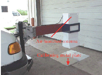
Figure 4-9. Detail view during calibration.
The 1-GHz antenna has a maximum penetration depth of about 24 in. The amount of energy returned and the time delay between reflections are used to calculate layer dielectrics and thickness. The dielectric constant of a material is an electrical property that is most influenced by moisture content and density. As the density and moisture content go up, the amount of energy reflected increases (and the penetrating ability decreases). Conversely, if the air voids increase, the amount of energy reflected decreases. Typical dielectric values for various pavement materials are given in Table 4-1 below:
Material | Dielectric | |
|---|---|---|
Typical Range | Signal Attenuation | |
HMA | 5 - 7 | Low |
HMA - stripped | < 4 | Low |
HMA w/light weight aggregate | 3 - 4 | Low |
HMA - wet (surface or voids) | > 8 | Moderate |
Open Graded Friction Course, Plant Mix Seal, Permeable Friction Course | 3.5 - 4.5 | Low |
OGFC w/light weight aggregate | 2 - 4 | Low |
Microsurfacing | 3.5 - 4.5 | Low |
Flex Base - dry | < 8 | Low |
Flex Base at optimum moisture content (OMC) | 8 - 12 | Low |
Flex Base - saturated | > 16 | High |
Cement Treated Base | 7 - 9 | Low |
Clay - wet | > 20 | High |
Concrete - old | 8 | Moderate |
Concrete - new | 10 - 20 | High |
Air | 1 | Low |
Water | 81 | High |
Ice | 3 | Low |
4.5.1 Analysis of GPR Data
Analysis of raw GPR data is accomplished using the . This program is available through the department’s MNT intranet page, under Engineering Applications. PaveCheck has the capability of evaluating and presenting both FWD deflection data and GPR data for the same project simultaneously. The is available through the same MNT intranet link. Also, basic concepts of GPR and example problems are presented in the
Flexible Pavement Rehabilitation Strategies training course
. This training aide is somewhat dated in that the older COLORMAP software (not compatible with current computer operating systems) is discussed. Because of the capabilities to compute material dielectric properties and layer thicknesses, GPR has become a valuable tool to the pavement engineer to assist in determining the following:- layer thicknesses, section changes, full-depth patches,
- location and extent of potential problems, such as elevated moisture levels or stripping in the HMA, and
- location/extent of segregation and low joint density.
Verification of suspected problem areas should be made with targeted coring and sampling. These sites should be selected based upon the analysis results from PaveCheck; locating potential coring sites based on radar signature patterns is facilitated by high definition video and GPS coordinates collected in the radar survey. Conclusions drawn from this limited sampling can then be applied with more confidence to the remainder of the survey.