Wave-Generated Currents
As wave energy enters the nearshore area, some of the energy is transformed into nearshore currents and is responsible for the movement of sediment. Wave-generated currents move both along the coast (longshore), parallel to the shoreline, and cross-shore, or perpendicular to the shoreline. Wave-generated currents in the nearshore environment are extremely complex and highly sensitive to wave direction and storm events. Currents are capable of moving large amounts of sediment over timescales ranging from hours (like during a storm event) to decades, making them important to consider in transportation infrastructure design. Understanding of the behavior of currents, including any associated local trends, is particularly important to determine necessary armoring needed to protect transportation assets from coastal erosion.
Longshore Currents
Longshore currents are generated by waves breaking at the shoreline (Figure 15-18). Longshore currents cause movement of sand along the beach, referred to as littoral drift or longshore sediment transport. The direction of longshore currents changes frequently in response to changes in wave approach angles but is generally associated with an average movement of sediment in one direction. This sediment movement contributes to the shoreline shape and evolution over time.
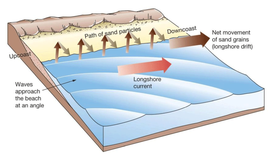
Figure 15-18. Diagram of Longshore Currents (Pearson Education, Inc., 2011)
During storm events, the rate of longshore sediment transport can be significant, causing erosion and scouring of engineered structures, including low-lying coastal roadways and bridge pilings. A single storm event can cause changes to the shoreline that take years to recover without intervention.
Longshore currents in the Gulf of Mexico impact the sediment movement along the Texas coast. The Texas coast experiences, in general, a longshore current from north to south for the upper Texas coast and another longshore current from south to north for the lower Texas coast. The currents converge around Padre Island near the upper Laguna Madre in Kenedy County. This helps to explain why beaches in the Coastal Bend, or middle Texas coast, are generally wide and ‘sediment rich’, whereas beaches located on the upper and lower coasts are ‘sediment starved’ and require more frequent renourishment. Upstream impacts caused by engineered structures (e.g., jetties capturing sand that would otherwise move downstream) can also have a major impact on shoreline positions.
The most common equation for estimating longshore sand transport rate is the ‘CERC Equation’, also known as the energy-flux method. This equation estimates the sediment transport rate based on the longshore component of energy flux or wave power entering the surf zone. This longshore transport calculation is most useful in understanding short-term fluctuations and sediment budgets for a project site. To understand longshore transport over long-term periods, historical imagery comparison is the most widely available data source, making it the primary resource. Details regarding calculation of the wave-energy flux factor and how it relates to longshore sediment transport can be found in
.
Cross-Shore Currents
In addition to longshore currents, breaking waves generate cross-shore currents that provide an offshore-directed flow of water and sediment entrained in the water column. Cross-shore currents are responsible for beach width changes following storm events, when large amounts of sediment may get pushed into deeper waters and be stored in the nearshore environment until they are slowly carried back to the beach face over the weeks or months following the event.
Rip currents, a unique type of cross-shore current, form in places where water that is driven ashore by strong waves in the presence of shallow sandbars drains back out to sea, creating a strong current perpendicular to the shoreline (Figure 15-19). Rip currents pull sand offshore, leaving behind recessional areas that can become ‘erosional hot spots’ where the beach is narrower. Low-lying roadways beyond these recesses are more vulnerable to erosion by larger waves. Although predicting where rip currents will appear is challenging, as they are poorly understood, advanced numerical models (refer to
Numerical Modeling of Waves
section) may be able to evaluate the storm conditions preferential to rip current development and provide insight on the potential scale of erosional hot spots that could develop. Local knowledge is also a key source of information that can indicate if rip currents are known to exist in a particular area. This information may be useful in developing coastal armoring for low-lying roadways located directly along coastlines.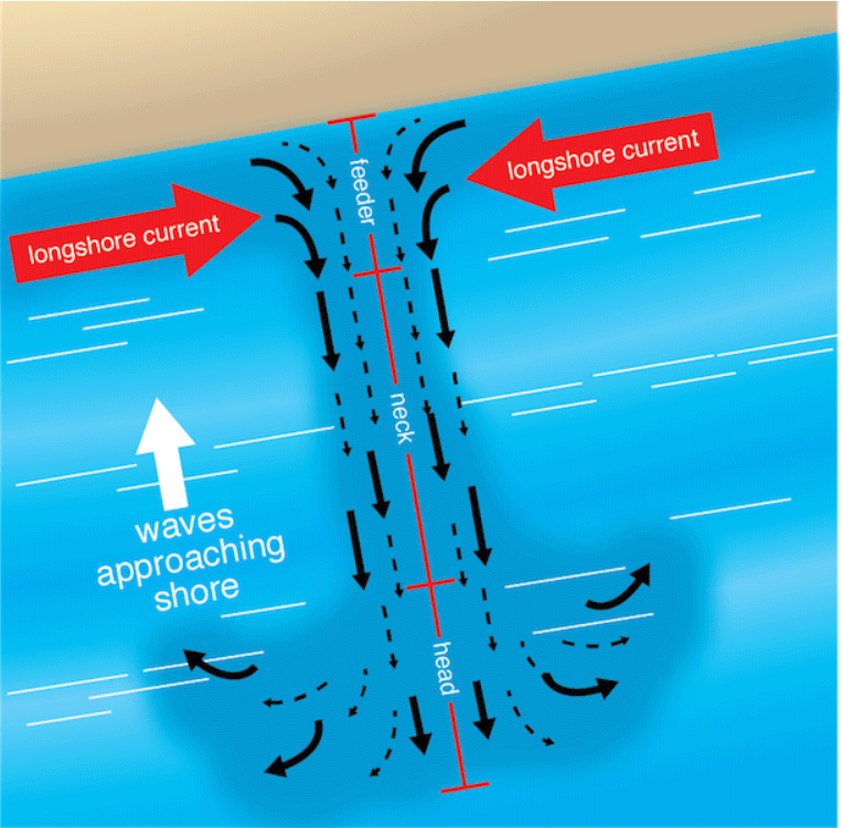
Figure 15-19. Diagram of Rip Currents (
)
Impacts on Coastal Structures
Wave-generated currents can be a concern for structural assets along the coast, primarily due to the potential to cause erosion. Both local scour on a bridge and the larger erosion potential of a shoreline should be considered as risks from wave generated currents. Likewise, the impacts on engineered structures should be considered with regards to how the infrastructure might change the existing wave and current patterns. If longshore sand transport is interrupted by a ship channel or other engineering projects, such as a jetty system to stabilize an inlet for shipping or large bridge pilings located in an area of littoral drift, erosion can occur for many miles down shore of the feature. Beaches adjacent to and near tidal inlets are part of a dynamic system influenced by water flowing into and out of the inlet and, therefore, exhibit much more shoreline change than beaches farther from inlets.
Engineered changes to the Gulf of Mexico-inlet-bay system include stabilizing the inlet with jetties or dredging the inlet or bay for navigation. Less obvious changes include the impacts of engineered structures in the bay that affect the amount of water leaving and entering the bay with each change of the tide. This can include filling of wetlands for coastal construction or constructing causeways in bays. Additional discussion on erosion mechanisms and mitigations measures will be discussed later in Section 5.
Currents Data Sources
- — NOAA Tides and Currents is a collection of NOAA wind, water level, and current data recording stations along U.S. coastlines. Current records are available at some of these recording stations, including locations in Galveston and near the Texas/Louisiana border.