Relative Sea Level Rise
Many of the roadway infrastructure networks located along the Texas shoreline have been in place since the early- to mid-1900s and were constructed with the underlying assumption that coastal water levels are stationary through time. Contemporary data trends in sea level rise call this assumption into question, resulting in uncertainty about the future performance of existing roadway infrastructure. Future sea level rise will increase the existing baseline elevations upon which daily tidal variations are measured and are therefore important to consider in project design.
Relative sea level rise reflects the combination of large-scale changes in global ocean levels (global mean sea level) and local changes in land elevations (for example, due to subsidence, or sinking, of land). Rates of relative sea level rise along the Texas coast are some of the highest in the nation: 4.0 mm/year (0.16 inches/year) at Port Isabel (1944-2018), 5.62 mm/year (0.22 inches/year) at Rockport (1948-2018), and 6.51 mm/year (0.24 inches/year) at Galveston Pleasure Pier (1908-2018) as shown in Figure 15-9 (
, 2019). These high rates of relative sea level rise are partially linked to subsidence exacerbated by the historical extraction of subsurface groundwater, oil, and gas.
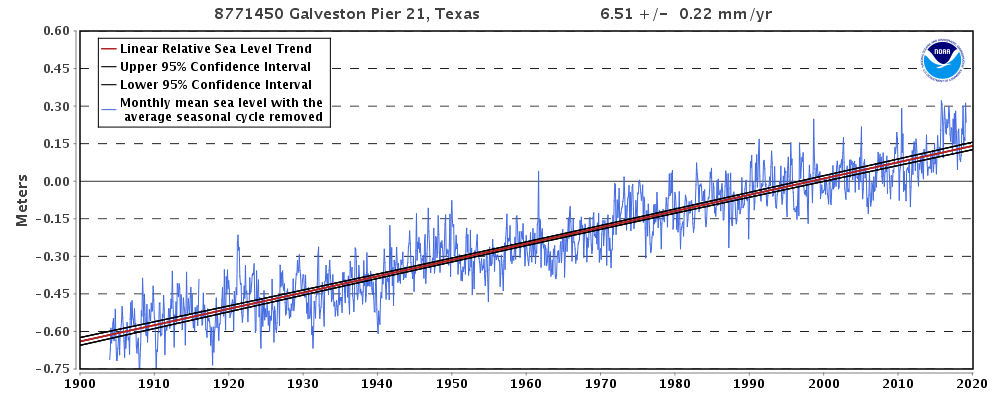
Figure 15-9. Historical Relative Sea Level Rise Rates at Galveston Pier 21 (
, 2019).
Figure 15-10 illustrates the projected sea level rise for points along the Texas coast in comparison to other national rates. Increases in relative sea level rise may have the following impacts on Texas transportation assets located in coastal areas:
- Roadway flooding.As coastal water levels increase, low-lying transportation routes may become exposed to more frequent and more intense flood events, interrupting roadway access and increasing maintenance costs.
- Efficiency of stormwater drainage.As low-lying stormwater outfalls become partially or completely inundated by rising coastal water levels, stormwater drainage may be impeded, resulting in roadway flooding. In addition, increases in coastal groundwater levels due to sea level rise may reduce the efficiency of existing stormwater drainage systems.
- Erosion damage.Elevated coastal water levels will allow wave action to reach higher elevations, which may cause erosion or scour near transportation features, such as unarmored embankments, causeways, and bridge pilings.
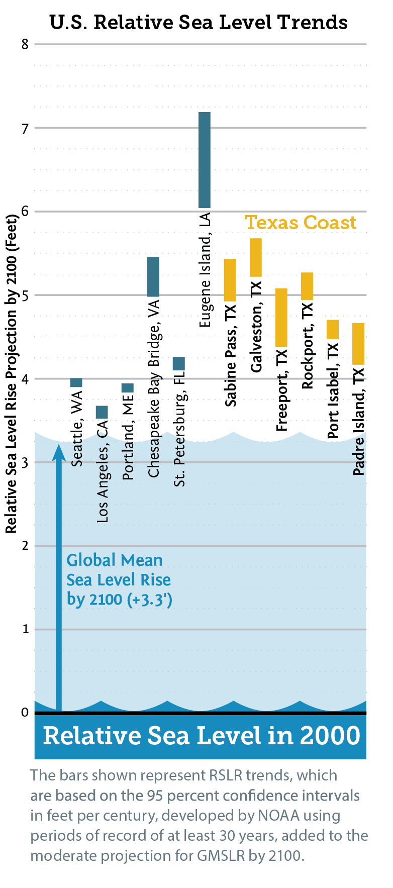
Figure 15-10. U.S. RSLR Trends
Due to the nature of transportation infrastructure (fixed alignment and elevation, linear features, long lifespan, etc.), assets are often limited in their ability to adapt to future sea level conditions. It is therefore important to incorporate future changes into project design whenever possible to cope with potential impacts of changing coastal conditions and minimize future cost and risk to these assets. Table 15-5 presents additional screening criteria that should be considered.
Factor to Consider | More Critical to Incorporate Sea Level Rise | Less Critical to Incorporate Sea Level Rise | |
|---|---|---|---|
1 | Project Design Life | Long (20+ years) | Short (less than 20 years) |
2 | Redundancy/ | No redundant/alternative route | Redundant/alternative route exists |
3 | Alternative Routes | Substantial delays | Minor or no delay |
4 | Anticipated Travel Delays Due to Sea Level Rise | Critical route for commercial goods movement | Non-critical route for commercial goods movement |
5 | Goods Movement | Vital for emergency evacuations | Minor or no delay in event of emergency |
6 | Evacuation/Emergency | Non-safety project | Safety project and delay would be substantial |
7 | Traveler Safety | Large investment | Small investment |
8 | (Delaying the Project to Incorporate Sea Level Rise would Lead to On-going or New Safety Concerns) | Minor or no effect – adjacent street and roads would not need to be modified | Substantial interconnectivity issues |
9 | Expenditure of Public Funds | Minor or no increase in project footprint in environmentally sensitive area | Substantial increase in project footprint in environmentally sensitive area |
10 | Interconnectivity Issues with Local Streets and Roads | Incorporating sea level rise may extend design into adjacent water bodies and/or properties or affect drainage of adjacent properties | Incorporating sea level rise will not have an impact on adjacent water bodies and/or properties |