Astronomical Tides
Water levels fluctuate throughout the day, primarily due to astronomical tides caused by the gravitational pull of the moon and sun. In Texas, long-term water level stations are available online through the National Oceanic and Atmospheric Administration (NOAA)
and the
(Figure 15 7). The Texas Gulf Coast generally experiences a diurnal pattern of one high and one low tide each day; however, there are times each month where semi-diurnal tides occur (two high and two low tides each day). The average daily tide range (difference between the average high tide and low tide) along the Texas coast averages less than 2 feet. Table 15-2 shows the tide ranges at representative locations along the coastline.
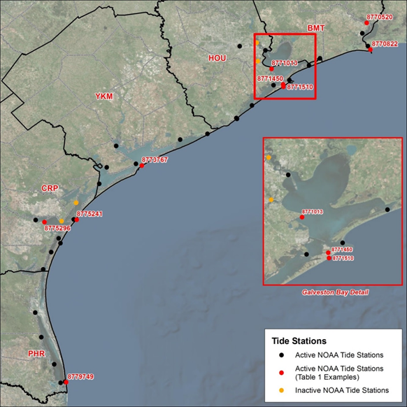
Figure 15-7. NOAA tide stations along the Texas Coast (USACE Galveston District Southwestern Division, 2018).
NOAA Station Name | Station Number | Tidal Range (feet) |
|---|---|---|
Rainbow Bridge, Port Arthur-Orange | 8770520 | 1.1 |
Texas Point, Sabine Pass | 8770822 | 2.0 |
Eagle Point, Galveston Bay | 8771013 | 1.1 |
Galveston Pleasure Pier | 8771510 | 2.0 |
Galveston Pier 21 | 8771450 | 1.4 |
Matagorda Bay Entrance Channel | 8773767 | 1.2 |
Aransas Pass, San Patricio County | 8775241 | 1.4 |
USS Lexington, Corpus Christi | 8775296 | 0.6 |
South Padre Island, Brazos Santiago | 8779749 | 1.4 |
NOTE: Tidal range reflects the great diurnal tidal range and is defined as the difference between Mean Higher High Water (MHHW) and Mean Lower Low Water (MLLW). | ||
Large differences in the tide range can occur at the same location throughout the month. During full and new moons, spring tides occur because the sun and moon are aligned with respect to the earth. Their combined gravity causes a larger than average tidal range: high tides are higher and low tides are lower. During quarter moons, neap tides occur when the gravity of the sun and moon are opposed, creating a smaller than average tidal range. More information on tides can be found the NOAA reference included in this section.
Tidal elevations also vary spatially and are influenced by local bathymetry, shoreline orientation, and wind/current patterns. Due to the complexities of the Texas shoreline, observed tide range varies locally, with some areas experiencing tidal amplification (e.g., Galveston Pleasure Pier), while others experience a dampening of the tidal signal (e.g., USS Lexington).
Annual High Tides
Annual high tides, also known as king tides, occur several days each year and produce ocean levels over a foot higher than average high tides along the Texas coastline.
Annual high tides often result in temporary flooding of low-lying coastlines, particularly if they coincide with a storm event or onshore wind that elevates tides above predicted levels. Because these tides can often cause nuisance flooding and reduce stormwater drainage efficiency, considering typical annual high tide elevations is especially important when designing low-lying roads and roadway drainage systems. In addition to temporary road closures, frequent flooding caused by these tides could lead to recurring damages to the roadway and increase the rate of scheduled maintenance.
Although most roadway infrastructure being constructed will be based on minimum design elevations that exceed the annual high tide, there may be cases where roadway assets remain vulnerable to flooding from annual high tide exposure (e.g., road repair or roadway culvert designs in rural areas). Therefore, it is recommended that the designer evaluates the design of the roadway project for potential exposure to annual high tide water level elevations and, where possible, construct roadway and drainage features at a higher relative elevation or design for the road base and support to account for frequent soil saturation. Care should also be taken to consider the hydraulic connectivity and ensure the proposed roadway does not obstruct the flow during or after high tide flooding events. The designer may consider incorporating some drainage features that will allow water to flow on either side of the asset.
Evaluating water levels collected at local tide stations during known annual high tide events provides a general range of expected water level events. Several approaches can be used to determine water elevations associated with an annual high tide event. Annual high tide events can be extracted using extreme value analysis of historical tide data observed at a local tide station.
Tidal Data Sources
- — NOAA Tides and Currents is a collection of wind, water level, and current data from NOAA recording stations along U.S. coastlines. Water level observations and tidal datums are available at some of these recording stations.
- — TCOON is a network of wind and water level observation stations along the Texas coast, with data collected by a combination of federal, state, local, and academic institutions. Water level observations and tidal datums are available at most TCOON recording stations.